跳转到内容

File:Greater Croatia 01.png

页面内容不支持其他语言。
这个文件来自维基共享资源
维基百科,自由的百科全书

原始文件 (1,151 × 1,041像素,文件大小:153 KB,MIME类型:image/png


摘要

描述
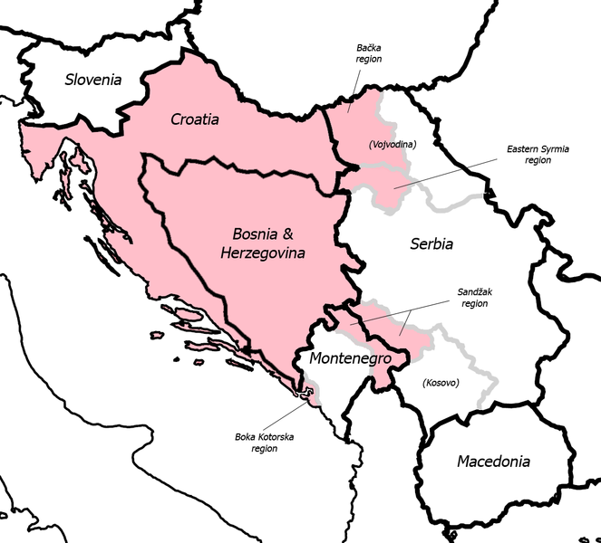
English: Fixed some detail, used overlaid Sandzak, Backa & Syrmium regions so it's much more accurate now. Pink coloring denotes regions claimed by Greater Croatian proponents. Current country borders are black, regional borders (only those that are relevant to the article) are grey.

Comment

Map is still wrong:) Croatian-Slovenian border in Istria is 20 kilometars southern that it should be (Umag and Savudrija are in Croatia, hej!) And borders of eastern Srijem are not correct (Zemun and Novi Beograd are part of Srijem, too).

I fixed the Istria issue, but keep in mind that this map is just a general illustration of the point in question, nothing more. Also, I don't think Belgrade region was ever claimed as a part of Greater Croatia (although anything is possible I guess) so I left it out. --Dr.Gonzo 10:52, 13 March 2007 (UTC)
My map at home has Croatia and Italy touching, so the Greater Croatia map on this page needs to cover a slice of Slovenia for that to be happening. The rest of the map is proportionate to the one I have. Plus doesn't it seem odd to anyone that on this map is no Slovenian territory claimed?
日期 2006年5月24日 (原始上传日期)
来源 Transferred from en.wikipedia to Commons.
作者 英语维基百科Dr.Gonzo
其他版本

许可协议

Public domain 本作品已被作者英语维基百科Dr.Gonzo释出到公有领域。这适用于全世界。
在一些国家这可能不合法;如果是这样的话,那么:
Dr.Gonzo无条件地授予任何人以任何目的使用本作品的权利,除非这些条件是法律规定所必需的。

原始上传日志

The original description page was here. All following user names refer to en.wikipedia.
  • 2007-03-13 10:42 Dr.Gonzo 1151×1041×8 (156832 bytes) Fixed the Istria border (sorry for that, the blank map I used already had that mistake)
  • 2006-05-24 22:25 Dr.Gonzo 1151×1041×8 (154088 bytes) Fixed some detail, used overlayed Sandzak, Backa & Syrmium regions so it's much more accurate now.
  • 2006-05-24 19:10 Dr.Gonzo 1151×1041×8 (153078 bytes) First version, self made. Some minor geographical detail may be incorrect. Pink coloring denotes regions claimed by Greater Croatian proponents.

说明

添加一行文字以描述该文件所表现的内容

此文件中描述的项目

描绘内容

文件历史

点击某个日期/时间查看对应时刻的文件。

日期/时间缩⁠略⁠图大小用户备注
当前2008年2月25日 (一) 22:402008年2月25日 (一) 22:40版本的缩略图1,151 × 1,041(153 KB)File Upload Bot (Magnus Manske) {{BotMoveToCommons|en.wikipedia}} {{Information |Description={{en|Fixed some detail, used overlaid Sandzak, Backa & Syrmium regions so it's much more accurate now. Pink coloring denotes regions claimed by Greater Croatian proponents. Current country bord

没有页面使用本文件。

全域文件用途

以下其他wiki使用此文件: