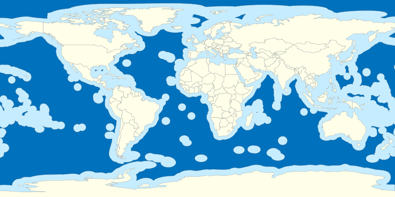
File:Exclusive Economic Zones.svg
外觀

此 SVG 檔案的 PNG 預覽的大小:800 × 400 像素。 其他解析度:320 × 160 像素 | 640 × 320 像素 | 1,024 × 512 像素 | 1,280 × 640 像素 | 2,560 × 1,280 像素。
原始檔案 (SVG 檔案,表面大小:800 × 400 像素,檔案大小:553 KB)
檔案歷史
點選日期/時間以檢視該時間的檔案版本。
| 日期/時間 | 縮圖 | 尺寸 | 用戶 | 備註 | |
|---|---|---|---|---|---|
| 目前 | 2020年5月12日 (二) 02:39 |  | 800 × 400(553 KB) | Ratherous | Sea of Okhotsk entirely Russian since 2014 |
| 2015年4月17日 (五) 00:07 |  | 800 × 400(552 KB) | B1mbo | m | |
| 2011年10月31日 (一) 21:59 |  | 800 × 400(552 KB) | B1mbo | =={{int:filedesc}}== {{Information |description={{es|1=Mapa de aguas internacionales en el mundo.}}{{en|1=Map of international waters in the world.}} |date=2011-10-31 |source={{own}}.<br/>Map from File:World location map.svg<br/>Borders based on [htt |
檔案用途
全域檔案使用狀況
以下其他 wiki 使用了這個檔案:
- cs.wikipedia.org 的使用狀況
- de.wikipedia.org 的使用狀況
- en.wikipedia.org 的使用狀況
- es.wikipedia.org 的使用狀況
- fa.wikipedia.org 的使用狀況
- fr.wikipedia.org 的使用狀況
- fr.wikiversity.org 的使用狀況
- hi.wikipedia.org 的使用狀況
- hy.wikipedia.org 的使用狀況
- id.wikipedia.org 的使用狀況
- io.wikipedia.org 的使用狀況
- it.wikipedia.org 的使用狀況
- Punto caldo del New England
- Great Meteor
- Myōjin-shō
- Jólnir
- Template:Acque internazionali
- Utente:Antonio1952/Bandierine
- Massiccio Tamu
- Template:Naz/Acque internazionali
- Axial Seamount
- Cobb Seamount
- Brown Bear Seamount
- Patton Seamount
- Bowie Seamount
- Hodgkins Seamount
- Peirce Seamount
- Denson Seamount
- Graham Seamount
- Oshawa Seamount
- Adams Seamount
- Bear Seamount
- Allegheny Seamount
- Asterias Seamount
- Balanus Seamount
- Buell Seamount
- Gerda Seamount
- Gilliss Seamount
檢視此檔案的更多全域使用狀況。


