Sterksel: Difference between revisions
Appearance
Content deleted Content added
Adding geodata: {{coor title dm|51|21|N|5|37|E|region:NL_type:city}} |
|||
| (19 intermediate revisions by 14 users not shown) | |||
| Line 1: | Line 1: | ||
{{Infobox settlement |
|||
| ⚫ | |||
<!-- Name and transliteration --> |
|||
| name = Sterksel |
|||
| settlement_type = Village |
|||
<!-- Images, nickname, motto --> |
|||
| image_skyline = File:Cafetaria De Scheep P1130464.jpg |
|||
| image_alt = |
|||
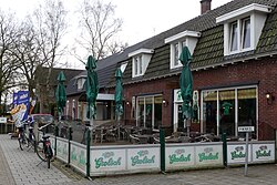
| image_caption = Snackbar in Sterksel |
|||
| image_flag = |
|||
| flag_size = |
|||
| flag_alt = |
|||
|image_shield = |
|||
<!-- Maps, coordinates --> |
|||
|image_map = |
|||
|pushpin_map = Netherlands North Brabant#Netherlands#Europe |
|||
|map_alt = |
|||
|map_caption = Location in North Brabant |
|||
|coordinates = {{coord |51|21|2|N|5|36|43|E|region:NL|display=inline, title}} |
|||
|coordinates_footnotes = |
|||
|subdivision_type = [[List of sovereign states|Country]] |
|||
|subdivision_name = [[Image:Flag of the Netherlands.svg|20px]] [[Netherlands]] |
|||
|subdivision_type1 = Province |
|||
|subdivision_name1 = [[Image:North Brabant-Flag.svg|20px]] [[North Brabant]] |
|||
|subdivision_type2 = Municipality |
|||
|subdivision_name2 = [[Image:Heeze-Leende vlag.svg |20px]] [[Heeze-Leende]] |
|||
<!-- Geographic information --> |
|||
| elevation_footnotes = <ref name="AHN">{{cite web |url = http://www.ahn.nl/postcodetool |title = Postcodetool for 6029PA |language = nl |work = Actueel Hoogtebestand Nederland |publisher = Het Waterschapshuis |access-date = 16 April 2022 }}</ref> |
|||
| elevation_m = 27 |
|||
| elevation_min_m = |
|||
| elevation_max_m = |
|||
| area_footnotes = <ref name="stat"/> |
|||
| area_total_km2 = 17.62 |
|||
| established_title = |
|||
| established_date = |
|||
| population_footnotes = <ref name="stat">{{cite web |url=https://www.cbs.nl/-/media/_excel/2021/48/kwb-2021.xls |title=Kerncijfers wijken en buurten 2021 |website=Central Bureau of Statistics |access-date=16 April 2022}}</ref> |
|||
| population_total = 1,785 |
|||
| population_as_of = 2021 |
|||
| population_demonym = |
|||
| population_note = |
|||
| population_density_km2 = auto |
|||
| timezone = [[Central European Time|CET]] |
|||
| utc_offset = +1 |
|||
| timezone_DST = [[Central European Summer Time|CEST]] |
|||
| utc_offset_DST = +2 |
|||
| postal_code_type = [[List of postal codes in the Netherlands|Postal code]] |
|||
| postal_code = 6029<ref name="stat"/> |
|||
| area_code_type = [[Telephone numbers in the Netherlands|Dialing code]] |
|||
| area_code = 040 |
|||
| website = https://www.sterksel.nu/ |
|||
}} |
|||
| ⚫ | |||
| ⚫ | |||
The spoken language is "Heeze-en-Leendes", a distinct dialect within the [[East Brabantian]] [[dialect]] group, quite similar to colloquial [[Dutch language|Dutch]]. |
|||
== History == |
|||
The village was first mentioned between 1196 and 1198 as Sterkesele. The suffix means "single roomed house". The first part can either be sterk (strong) or sterke (young cow).<ref>{{cite web|url=https://etymologiebank.nl/trefwoord/sterksel2 |title=Sterksel - (geografische naam) |website=Etymologiebank |access-date=16 April 2022 |language=nl}}</ref> Sterksel is an agricultural community from the Middle Ages. Between 1798 until 1915, it was owned by the Pompen family.<ref name="monument">{{cite book|url=https://dbnl.org/tekst/sten009monu02_01/sten009monu02_01_0166.php |title=Sterksel |author=Chris Kolman & Ronald Stenvert| year=1997 |publisher=Waanders |location=Zwolle |isbn=90 400 9945 6 |access-date=16 April 2022 |language=nl}}</ref> |
|||
Sterksel was home to 99 people in 1840.<ref name="plaats">{{cite web|url=https://www.plaatsengids.nl/sterksel |title=Sterksel |website=Plaatsengids |access-date=16 April 2022 |language=nl}}</ref> Broederhuis Providentia is a monastery established in 1915.<ref name="monument"/> |
|||
== Gallery == |
|||
<gallery> |
|||
File:Sterksel, de Sint-Catharinakerk GM1658-WN031 IMG 3707 2022-10-30 11.30.jpg|St Catharina Church |
|||
File:Beukenlaan 30, Sterksel (2).JPG|Villa Ekelhof |
|||
File:Oostrikkerweg 1, Sterksel.JPG|House in Sterksel |
|||
File:Woningen winkels Sterksel P1130439.jpg|Supermarket |
|||
</gallery> |
|||
== References == |
|||
{{RefList}} |
|||
| ⚫ | |||
*[http://www.sterksel.nu/ Official Website] |
*[http://www.sterksel.nu/ Official Website] |
||
{{Authority control}} |
|||
{{Province North Brabant}} |
|||
| ⚫ | |||
{{coor title dm|51|21|N|5|37|E|region:NL_type:city}} |
|||
| ⚫ | |||
| ⚫ | |||
{{NorthBrabant-geo-stub}} |
|||
| ⚫ | |||
[[id:Heeze-Leende]] |
|||
[[it:Heeze-Leende]] |
|||
[[li:Heeze-Leende]] |
|||
[[nl:Heeze-Leende]] |
|||
[[sv:Heeze-Leende]] |
|||
Latest revision as of 22:19, 28 January 2023
Sterksel | |
|---|---|
Village | |
 Snackbar in Sterksel | |
| Coordinates: 51°21′2″N 5°36′43″E / 51.35056°N 5.61194°E | |
| Country | |
| Province | |
| Municipality | |
| Area | |
• Total | 17.62 km2 (6.80 sq mi) |
| Elevation | 27 m (89 ft) |
| Population (2021)[1] | |
• Total | 1,785 |
| • Density | 100/km2 (260/sq mi) |
| Time zone | UTC+1 (CET) |
| • Summer (DST) | UTC+2 (CEST) |
| Postal code | 6029[1] |
| Dialing code | 040 |
| Website | https://www.sterksel.nu/ |
Sterksel is a village in the southern Netherlands, near Eindhoven. It lies within the municipality Heeze-Leende. It's the smallest village of three in the municipality. The spoken language is "Heeze-en-Leendes", a distinct dialect within the East Brabantian dialect group, quite similar to colloquial Dutch.
History
[edit]The village was first mentioned between 1196 and 1198 as Sterkesele. The suffix means "single roomed house". The first part can either be sterk (strong) or sterke (young cow).[3] Sterksel is an agricultural community from the Middle Ages. Between 1798 until 1915, it was owned by the Pompen family.[4]
Sterksel was home to 99 people in 1840.[5] Broederhuis Providentia is a monastery established in 1915.[4]
Gallery
[edit]-
St Catharina Church
-
Villa Ekelhof
-
House in Sterksel
-
Supermarket
References
[edit]- ^ a b c "Kerncijfers wijken en buurten 2021". Central Bureau of Statistics. Retrieved 16 April 2022.
- ^ "Postcodetool for 6029PA". Actueel Hoogtebestand Nederland (in Dutch). Het Waterschapshuis. Retrieved 16 April 2022.
- ^ "Sterksel - (geografische naam)". Etymologiebank (in Dutch). Retrieved 16 April 2022.
- ^ a b Chris Kolman & Ronald Stenvert (1997). Sterksel (in Dutch). Zwolle: Waanders. ISBN 90 400 9945 6. Retrieved 16 April 2022.
- ^ "Sterksel". Plaatsengids (in Dutch). Retrieved 16 April 2022.
External links
[edit]


