Kouhu: Difference between revisions
Rescuing 1 sources and tagging 0 as dead.) #IABot (v2.0.9.4 |
(from mandarin page) updated population stats, updated transportation & history, minor copyedits |
||
| (3 intermediate revisions by one other user not shown) | |||
| Line 37: | Line 37: | ||
| population_as_of = February 2023 |
| population_as_of = February 2023 |
||
| population_footnotes = |
| population_footnotes = |
||
| population_total = 24882<ref>{{cite web |title=村里鄰人口數 |url=https://beigang.household.yunlin.gov.tw/popul01/index.aspx?Parser=99,5,40 |publisher=Beigang Household Registration Office |access-date=15 May 2024}}</ref> |
|||
| population_total = 25454 |
|||
| population_urban = |
| population_urban = |
||
| population_metro = |
| population_metro = |
||
| Line 53: | Line 53: | ||
}} |
}} |
||
'''Kouhu Township''' ({{zh|c=口湖鄉|p=Kǒuhú Xiāng}}) is a [[Township (Taiwan)|rural township]] in [[Yunlin County]], [[Taiwan]]. |
'''Kouhu Township''' ({{zh|c=口湖鄉|p=Kǒuhú Xiāng}}) is a [[Township (Taiwan)|rural township]] in [[Yunlin County]], [[Taiwan]]. It is known for seafood products such as [[red algae]], [[eel]], and [[karasumi]].<ref>{{cite web |title=口湖特產 |url=https://www.kouhu.gov.tw/page/%E5%8F%A3%E6%B9%96%E7%89%B9%E7%94%A2/105 |publisher=雲林縣口湖鄉公所 |access-date=15 May 2024}}</ref> |
||
==Geography== |
==Geography== |
||
[[File:Txu-oclc-6557994-index-451.jpg|left|thumb|Map including Kouhu (labeled as K'ou-hu (Kōko) {{lang|zh-tw|口湖}}) (1950)]] |
[[File:Txu-oclc-6557994-index-451.jpg|left|thumb|Map including Kouhu (labeled as K'ou-hu (Kōko) {{lang|zh-tw|口湖}}) (1950)]] |
||
It has a population total of |
It has a population total of 24,882 and an area of 80.4612 square kilometers, including a section of coastline bordering the [[Taiwan Strait]]. |
||
==History== |
==History== |
||
Owing to the existence of a large lagoon shaped like an elephant's trunk in the area, Kouhu was known as Xiangbihu (Elephant Trunk Lake) in the late Ming and Qing periods.<ref>{{cite web |title=歷史地理沿革 |url=https://www.kouhu.gov.tw/page/%E6%AD%B7%E5%8F%B2%E5%9C%B0%E7%90%86%E6%B2%BF%E9%9D%A9/4 |publisher=雲林縣口湖鄉公所 |access-date=15 May 2024}}</ref> |
|||
Kouhu's coastal waters were traditionally used in [[oyster farming]], but in 1991 they were [[zoning|zoned]] for offshore industrial use.<ref>{{cite web|url=http://www.taipeitimes.com/News/taiwan/archives/2015/08/19/2003625714|title=Yunlin commissioner pleads oyster farmers’ case|work=taipeitimes.com|access-date=2017-01-30}}</ref> |
Kouhu's coastal waters were traditionally used in [[oyster farming]], but in 1991 they were [[zoning|zoned]] for offshore industrial use.<ref>{{cite web|url=http://www.taipeitimes.com/News/taiwan/archives/2015/08/19/2003625714|title=Yunlin commissioner pleads oyster farmers’ case|work=taipeitimes.com|access-date=2017-01-30}}</ref> |
||
| Line 66: | Line 68: | ||
==Infrastructure== |
==Infrastructure== |
||
Kouhu is one of the |
Kouhu is one of the areas proposed by the [[Taiwan Power Company]] for an [[Submarine power cable|underground electricity cable]] connecting it with Jianshan Village in [[Penghu]]'s [[Husi, Penghu|Huxi Township]].<ref>{{cite web|url=http://www.taipeitimes.com/News/taiwan/archives/2014/01/28/2003582337/1|title=EPA gives green light for projects - Taipei Times}}</ref> |
||
==Festivals== |
==Festivals== |
||
| Line 77: | Line 79: | ||
==Transportation== |
==Transportation== |
||
*[[Provincial Highway 61 (Taiwan)|Provincial Highway 61]] |
*[[Provincial Highway 61 (Taiwan)|Provincial Highway 61]] |
||
*[[Provincial Highway 17 (Taiwan)]] |
|||
* [[County Highway 164]] |
|||
==Climate== |
|||
{{Weather box|width=auto |
|||
|metric first=y |
|||
|single line=y |
|||
|collapsed = Y |
|||
|location = Kouhu (2019–2023, extremes 2019–present) |
|||
|Jan high C = 20.4 |
|||
|Feb high C = 21.4 |
|||
|Mar high C = 24.4 |
|||
|Apr high C = 26.4 |
|||
|May high C = 28.8 |
|||
|Jun high C = 30.9 |
|||
|Jul high C = 31.7 |
|||
|Aug high C = 31.2 |
|||
|Sep high C = 31.2 |
|||
|Oct high C = 28.8 |
|||
|Nov high C = 26.1 |
|||
|Dec high C = 21.7 |
|||
|Jan mean C = 16.9 |
|||
|Feb mean C = 17.7 |
|||
|Mar mean C = 20.5 |
|||
|Apr mean C = 23.0 |
|||
|May mean C = 25.9 |
|||
|Jun mean C = 28.2 |
|||
|Jul mean C = 28.9 |
|||
|Aug mean C = 28.4 |
|||
|Sep mean C = 27.9 |
|||
|Oct mean C = 25.3 |
|||
|Nov mean C = 22.5 |
|||
|Dec mean C = 18.5 |
|||
|Jan low C = 14.4 |
|||
|Feb low C = 15.0 |
|||
|Mar low C = 17.6 |
|||
|Apr low C = 20.2 |
|||
|May low C = 23.4 |
|||
|Jun low C = 25.7 |
|||
|Jul low C = 26.3 |
|||
|Aug low C = 26.0 |
|||
|Sep low C = 25.3 |
|||
|Oct low C = 22.7 |
|||
|Nov low C = 19.7 |
|||
|Dec low C = 16.0 |
|||
|Jan record high C = 28.2 |Jan record low C = 7.5 |
|||
|Feb record high C = 30.3 |Feb record low C = 8.1 |
|||
|Mar record high C = 30.2 |Mar record low C = 12.0 |
|||
|Apr record high C = 30.5 |Apr record low C = 12.3 |
|||
|May record high C = 32.1 |May record low C = 16.2 |
|||
|Jun record high C = 33.0 |Jun record low C = 22.6 |
|||
|Jul record high C = 34.3 |Jul record low C = 23.2 |
|||
|Aug record high C = 33.4 |Aug record low C = 23.8 |
|||
|Sep record high C = 33.7 |Sep record low C = 21.2 |
|||
|Oct record high C = 32.6 |Oct record low C = 18.7 |
|||
|Nov record high C = 30.8 |Nov record low C = 12.3 |
|||
|Dec record high C = 29.3 |Dec record low C = 8.3 |
|||
|year record high C = |year record low C = |
|||
|precipitation colour = green |
|||
|Jan precipitation mm = 23.2 |
|||
|Feb precipitation mm = 22.1 |
|||
|Mar precipitation mm = 49.8 |
|||
|Apr precipitation mm = 68.9 |
|||
|May precipitation mm = 137.8 |
|||
|Jun precipitation mm = 268.1 |
|||
|Jul precipitation mm = 182.8 |
|||
|Aug precipitation mm = 314.4 |
|||
|Sep precipitation mm = 86.4 |
|||
|Oct precipitation mm = 17.0 |
|||
|Nov precipitation mm = 13.0 |
|||
|Dec precipitation mm = 27.0 |
|||
|Jan precipitation days = 4.9 |
|||
|Feb precipitation days = 4.4 |
|||
|Mar precipitation days = 6.5 |
|||
|Apr precipitation days = 5.0 |
|||
|May precipitation days = 8.0 |
|||
|Jun precipitation days = 12.5 |
|||
|Jul precipitation days = 10.9 |
|||
|Aug precipitation days = 13.4 |
|||
|Sep precipitation days = 5.8 |
|||
|Oct precipitation days = 2.5 |
|||
|Nov precipitation days = 2.9 |
|||
|Dec precipitation days = 2.6 |
|||
|year precipitation days = |
|||
|Jan humidity = 75.4 |
|||
|Feb humidity = 76.4 |
|||
|Mar humidity = 75.5 |
|||
|Apr humidity = 74.0 |
|||
|May humidity = 77.8 |
|||
|Jun humidity = 77.8 |
|||
|Jul humidity = 76.0 |
|||
|Aug humidity = 78.4 |
|||
|Sep humidity = 74.4 |
|||
|Oct humidity = 73.2 |
|||
|Nov humidity = 74.8 |
|||
|Dec humidity = 73.6 |
|||
|source 1 = Central Weather Administration<ref name= CWA>{{cite web |
|||
|url = https://agr.cwa.gov.tw/NAGR/history/station_day |
|||
| title = 農業氣象觀測網監測系統 : 口湖工作站(12J990) |
|||
| publisher= Central Weather Administration |
|||
|access-date = 20 April 2024 }}</ref> |
|||
|source 2 = Atmospheric Science Research and Application Databank (precipitation 2016–2023)<ref name= ASRAD>{{cite web |url = https://asrad.pccu.edu.tw/catalog/clim/ |
|||
| title = 中央氣象署 測站氣候資料 : 雲林口湖 C1K540 |
|||
| publisher= Atmospheric Science Research and Application Databank |
|||
|access-date = 20 April 2024 }}</ref> |
|||
}} |
|||
==See also== |
==See also== |
||
Latest revision as of 03:12, 15 May 2024
23°34′35″N 120°10′21″E / 23.57626°N 120.172523°E
Kouhu Township 口湖鄉 | |
|---|---|
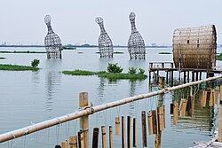
 Chenglong Wetlands in Kouhu Township | |
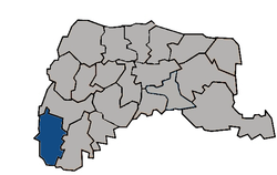
 Kouhu Township in Yunlin County | |
| Location | Yunlin County, Taiwan |
| Area | |
• Total | 80 km2 (30 sq mi) |
| Population (February 2023) | |
• Total | 24,882[1] |
Kouhu Township (Chinese: 口湖鄉; pinyin: Kǒuhú Xiāng) is a rural township in Yunlin County, Taiwan. It is known for seafood products such as red algae, eel, and karasumi.[2]
Geography
[edit]
It has a population total of 24,882 and an area of 80.4612 square kilometers, including a section of coastline bordering the Taiwan Strait.
History
[edit]Owing to the existence of a large lagoon shaped like an elephant's trunk in the area, Kouhu was known as Xiangbihu (Elephant Trunk Lake) in the late Ming and Qing periods.[3]
Kouhu's coastal waters were traditionally used in oyster farming, but in 1991 they were zoned for offshore industrial use.[4]
Administrative divisions
[edit]The township comprises 21 villages: Chenglong, Dinghu, Gangtung, Gangxi, Guogang, Houcuo, Hukou, Hutung, Jinghan, Keliao, Kouhu, Luntung, Lunjhong, Pubei, Punan, Shueijing, Sialun, Siecuo, Taizih, Wubei, and Wunan.
Infrastructure
[edit]Kouhu is one of the areas proposed by the Taiwan Power Company for an underground electricity cable connecting it with Jianshan Village in Penghu's Huxi Township.[5]
Festivals
[edit]Tourist attractions
[edit]Transportation
[edit]Climate
[edit]| Climate data for Kouhu (2019–2023, extremes 2019–present) | |||||||||||||
|---|---|---|---|---|---|---|---|---|---|---|---|---|---|
| Month | Jan | Feb | Mar | Apr | May | Jun | Jul | Aug | Sep | Oct | Nov | Dec | Year |
| Record high °C (°F) | 28.2 (82.8) |
30.3 (86.5) |
30.2 (86.4) |
30.5 (86.9) |
32.1 (89.8) |
33.0 (91.4) |
34.3 (93.7) |
33.4 (92.1) |
33.7 (92.7) |
32.6 (90.7) |
30.8 (87.4) |
29.3 (84.7) |
34.3 (93.7) |
| Mean daily maximum °C (°F) | 20.4 (68.7) |
21.4 (70.5) |
24.4 (75.9) |
26.4 (79.5) |
28.8 (83.8) |
30.9 (87.6) |
31.7 (89.1) |
31.2 (88.2) |
31.2 (88.2) |
28.8 (83.8) |
26.1 (79.0) |
21.7 (71.1) |
26.9 (80.5) |
| Daily mean °C (°F) | 16.9 (62.4) |
17.7 (63.9) |
20.5 (68.9) |
23.0 (73.4) |
25.9 (78.6) |
28.2 (82.8) |
28.9 (84.0) |
28.4 (83.1) |
27.9 (82.2) |
25.3 (77.5) |
22.5 (72.5) |
18.5 (65.3) |
23.6 (74.6) |
| Mean daily minimum °C (°F) | 14.4 (57.9) |
15.0 (59.0) |
17.6 (63.7) |
20.2 (68.4) |
23.4 (74.1) |
25.7 (78.3) |
26.3 (79.3) |
26.0 (78.8) |
25.3 (77.5) |
22.7 (72.9) |
19.7 (67.5) |
16.0 (60.8) |
21.0 (69.9) |
| Record low °C (°F) | 7.5 (45.5) |
8.1 (46.6) |
12.0 (53.6) |
12.3 (54.1) |
16.2 (61.2) |
22.6 (72.7) |
23.2 (73.8) |
23.8 (74.8) |
21.2 (70.2) |
18.7 (65.7) |
12.3 (54.1) |
8.3 (46.9) |
7.5 (45.5) |
| Average precipitation mm (inches) | 23.2 (0.91) |
22.1 (0.87) |
49.8 (1.96) |
68.9 (2.71) |
137.8 (5.43) |
268.1 (10.56) |
182.8 (7.20) |
314.4 (12.38) |
86.4 (3.40) |
17.0 (0.67) |
13.0 (0.51) |
27.0 (1.06) |
1,210.5 (47.66) |
| Average precipitation days | 4.9 | 4.4 | 6.5 | 5.0 | 8.0 | 12.5 | 10.9 | 13.4 | 5.8 | 2.5 | 2.9 | 2.6 | 79.4 |
| Average relative humidity (%) | 75.4 | 76.4 | 75.5 | 74.0 | 77.8 | 77.8 | 76.0 | 78.4 | 74.4 | 73.2 | 74.8 | 73.6 | 75.6 |
| Source 1: Central Weather Administration[8] | |||||||||||||
| Source 2: Atmospheric Science Research and Application Databank (precipitation 2016–2023)[9] | |||||||||||||
See also
[edit]References
[edit]- ^ "村里鄰人口數". Beigang Household Registration Office. Retrieved 15 May 2024.
- ^ "口湖特產". 雲林縣口湖鄉公所. Retrieved 15 May 2024.
- ^ "歷史地理沿革". 雲林縣口湖鄉公所. Retrieved 15 May 2024.
- ^ "Yunlin commissioner pleads oyster farmers' case". taipeitimes.com. Retrieved 2017-01-30.
- ^ "EPA gives green light for projects - Taipei Times".
- ^ Yunlin, Cultural Tours in (31 May 2016). "Kouhu Township Qian Shui Che Zhuang Cultural Festival".
- ^ "Art exhibition listings - Taipei Times".
- ^ "農業氣象觀測網監測系統 : 口湖工作站(12J990)". Central Weather Administration. Retrieved 20 April 2024.
- ^ "中央氣象署 測站氣候資料 : 雲林口湖 C1K540". Atmospheric Science Research and Application Databank. Retrieved 20 April 2024.
External links
[edit]- Kouhu Township Office, Yunlin County Archived 2007-03-15 at the Wayback Machine (in Chinese)

