Daren, Taitung
22°18′N 120°53′E / 22.300°N 120.883°E
Daren Township 達仁鄉 | |
|---|---|
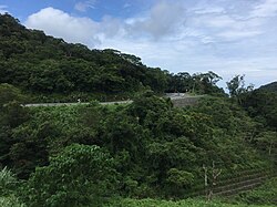
 View of the South-Link Highway | |
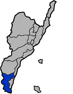
 Daren Township in Taitung County | |
| Location | Taitung County, Taiwan |
| Area | |
• Total | 306 km2 (118 sq mi) |
| Population (September 2023) | |
• Total | 3,419 |
Daren Township (Chinese: 達仁鄉; pinyin: Dárén Xiāng; Wade–Giles: Ta2-jen2 Hsiang1) is a mountain indigenous township in Taitung County, Taiwan. The main population is the Paiwan people of the Taiwanese aborigines.
History
[edit]In 2012, Daren, along with Wuqiu Township in Kinmen County (Quemoy), was proposed by the Ministry of Economic Affairs as the candidate of the new disposal site of nuclear waste after the Lanyu Storage Site in Orchid Island, Taitung County. This proposal however received heavy objection from the local Wuqiu residents.[1]
Geography
[edit]- Area: 306.4454 km2
- Population: 3,419 people (as of September 2023)
Administrative divisions
[edit]The township comprises six villages: Anshuo, Nantan, Senyong, Sinhua, Taiban and Tuban.[2]
Tourist attractions
[edit]- Dawu Keteleeria Nature Preservation Area
- Jinshueiying National Trail
- Nantian Coast Water Park
- Tjuwabal Paiwan Culture and Art Community
Transportation
[edit]The South-Link Highway passes through Daren Township, intersecting Highway 26 at Ansuo.
References
[edit]- ^ (Taiwan), Ministry of Foreign Affairs, Republic of China (22 May 2012). "Referendums to decide Taiwan's nuclear waste storage site - Taiwan Today". Taiwan Today. Retrieved 23 April 2018.
{{cite web}}: CS1 maint: multiple names: authors list (link) - ^ "Daren Township". Tour.taitung.gov.tw. Archived from the original on 2014-02-02. Retrieved 2014-05-14.
External links
[edit]


