Cové: Difference between revisions
Replacing geodata: {{coord|7|14|N|2|18|E|region:BJ_type:city|display=title}} |
RodRabelo7 (talk | contribs) |
||
| (39 intermediate revisions by 26 users not shown) | |||
| Line 1: | Line 1: | ||
{{Use dmy dates|date=May 2014}} |
|||
[[Image:BJ-Cove.png|right|125px|Location of Cové in Benin]] |
|||
{{Infobox settlement |
|||
'''Cové''' is a city located in the [[Zou Department]] of [[Benin]]. |
|||
<!--See the Table at Infobox Settlement for all fields and descriptions of usage--> |
|||
|name = Cové |
|||
|other_name = |
|||
|native_name = <!-- for cities whose native name is not in English --> |
|||
|nickname = |
|||
|settlement_type =[[Communes of Benin|Commune]] and [[List of cities in Benin|city]] |
|||
|motto = |
|||
|image_skyline = Cové1.jpg |
|||
|imagesize = |
|||
|image_caption = |
|||
|image_flag = |
|||
|flag_size = |
|||
|image_seal = |
|||
|seal_size = |
|||
|image_shield = |
|||
|shield_size = |
|||
|image_map = |
|||
|mapsize = |
|||
|map_caption = |
|||
|pushpin_map = Benin |
|||
|pushpin_label_position =bottom |
|||
|pushpin_mapsize =240 |
|||
|pushpin_map_caption =Location in Benin |
|||
|subdivision_type = Country |
|||
|subdivision_name = {{flag|Benin}} |
|||
|subdivision_type1 = [[Departments of Benin|Department]] |
|||
|subdivision_name1 = [[Zou Department]] |
|||
|subdivision_type2 = |
|||
|subdivision_name2 = |
|||
|subdivision_type3 = |
|||
|subdivision_name3 = |
|||
| |
|||
|government_footnotes = |
|||
|government_type = |
|||
|leader_title = |
|||
|leader_name = |
|||
|leader_title1 = <!-- for places with, say, both a mayor and a city manager --> |
|||
|leader_name1 = |
|||
|established_title = <!-- Settled --> |
|||
|established_date = |
|||
|area_magnitude = |
|||
|area_footnotes = |
|||
|area_total_km2 =525 <!-- ALL fields dealing with a measurements are subject to automatic unit conversion--> |
|||
|area_land_km2 = |
|||
|population_as_of =2012 |
|||
|population_footnotes =<ref>{{cite web|url=http://www.world-gazetteer.com/wg.php?x=&men=gcis&lng=en&des=wg&geo=-35&srt=npan&col=abcdefghinoq&msz=1500&pt=c&va=&srt=pnan|title=World Gazeteer|archive-url=https://archive.today/20130111114716/http://www.world-gazetteer.com/wg.php?x=&men=gcis&lng=en&des=wg&geo=-35&srt=npan&col=abcdefghinoq&msz=1500&pt=c&va=&srt=pnan|archive-date=11 January 2013}}</ref> |
|||
|population_note = |
|||
|population_total =43554 |
|||
|population_density_km2 =auto |
|||
|population_density_sq_mi = |
|||
|population_metro = |
|||
|population_density_metro_km2 = |
|||
|population_density_metro_sq_mi = |
|||
|population_blank1_title =Ethnicities |
|||
|population_blank1 = |
|||
|population_density_blank1_km2 = |
|||
|population_density_blank1_sq_mi = |
|||
|timezone =[[West Africa Time|WAT]] |
|||
|utc_offset = +1 |
|||
|timezone_DST = |
|||
|utc_offset_DST = |
|||
|coordinates = {{coord|7|14|N|2|18|E|region:BJ|display=inline}} |
|||
|elevation_footnotes = |
|||
|elevation_m = |
|||
|elevation_ft = |
|||
|postal_code_type = <!-- enter ZIP code, Postcode, Post code, Postal code... --> |
|||
|postal_code = |
|||
|area_code = |
|||
|blank_name = |
|||
|blank_info = |
|||
|blank1_name = |
|||
|blank1_info = |
|||
|website = |
|||
|footnotes = |
|||
}} |
|||
'''Cové''' {{IPA|fr|kɔ.ve|}} is a city in the [[Zou Department]] of [[Benin]]. The commune covers an area of 525 square kilometres and as of 2012 had a population of 43,554 people.<ref name="Atlasbenin">{{cite web|url=http://atlasbenin.africa-web.org/Zou/Cove.htm|archive-url=https://web.archive.org/web/20210509054401/http://atlasbenin.africa-web.org/Zou/Cove.htm|url-status=dead|archive-date=9 May 2021|title=Cove|publisher=Atlas Monographique des Communes du Benin|access-date=5 January 2010}}</ref><ref>{{cite web|url=http://www.statoids.com/ybj.html |title=Communes of Benin |publisher=Statoids |access-date=5 January 2010 |archive-url=https://web.archive.org/web/20120324053222/http://www.statoids.com/ybj.html |archive-date=24 March 2012 |url-status=dead |df=dmy }}</ref> |
|||
{{Benin-geo-stub}} |
|||
==Geography== |
|||
Cové is located 40 kilometres from [[Abomey]] and 159 kilometres from [[Cotonou]]. The commune covers an area of 525 square kilometres and the Zou Ouémé river passes through it. It is bounded to the north by [[Dassa-Zoumé]], east by [[Zagnanado]], south by [[Zogbodomey]], and west by [[Djidja]] and [[Za-Kpota]]. It is linked to the capital by a paved road.<ref name="Commune">{{cite web|url=http://www.cove.communedubenin.org/|title=Cove|publisher=www.cove.communedubenin.org|access-date=8 January 2009|archive-url=https://web.archive.org/web/20130905163933/http://www.cove.communedubenin.org/|archive-date=5 September 2013}}</ref> |
|||
Cové became a sub-prefecture in 1991. |
|||
==Administrative divisions== |
|||
[[File:Cové2.jpg|left|260px]] |
|||
Cové is subdivided into 7 arrondissements; [[Adogbé]], [[Gounli]], [[Houin]], [[Lainta]], [[Naogon]], [[Soli, Benin|Soli]] and [[Zogba]]. They contain 36 ''quartiers''.<ref name="Atlasbenin"/> |
|||
==Economy== |
|||
The main ethnic groups are the [[Mahi people|Mahi]], the [[Fon people|Fon]], [[Yoruba people|Yoruba]], [[Dendi people|Dendi]] and [[Bariba people|Bariba]]. The occupations of the inhabitants are agriculture, fishing and hunting (42%), trade and catering (30%), transport and communication (6%) crafts (11%) etc.<ref name="Commune"/> 53 600,00 hectares of land are devoted to agriculture, accounting for 93.38% of the total population.<ref name="Atlasbenin"/> The main crops grown are [[maize]], [[cotton]], [[peanut]]s, [[cassava]] and [[rice]].<ref name="Atlasbenin"/>[[File:Cové3.jpg|left|260px]] |
|||
==Gelede Masked Festival gallery== |
|||
<gallery> |
|||
File:Cové4.jpg| |
|||
File:Cové5.jpg| |
|||
</gallery> |
|||
==References== |
|||
{{Reflist}} |
|||
{{commons category}} |
|||
{{coord|7|14|N|2|18|E|region:BJ_type:city|display=title}} |
{{coord|7|14|N|2|18|E|region:BJ_type:city|display=title}} |
||
{{Communes of Benin}} |
|||
{{Zou Department}} |
|||
[[Category:Cities, towns and villages in Benin]] |
|||
{{DEFAULTSORT:Cove}} |
|||
[[fr:Covè]] |
|||
[[Category:Communes of Benin]] |
|||
[[ro:Cové]] |
|||
[[Category:Arrondissements of Benin]] |
|||
[[Category:Populated places in the Zou Department]] |
|||
Latest revision as of 07:57, 22 August 2024
Cové | |
|---|---|
 | |
| Coordinates: 7°14′N 2°18′E / 7.233°N 2.300°E | |
| Country | |
| Department | Zou Department |
| Area | |
• Total | 525 km2 (203 sq mi) |
| Population (2012)[1] | |
• Total | 43,554 |
| • Density | 83/km2 (210/sq mi) |
| Time zone | UTC+1 (WAT) |
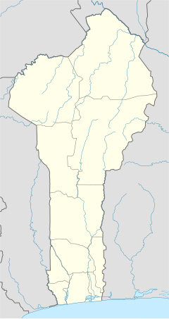
Cové [kɔ.ve] is a city in the Zou Department of Benin. The commune covers an area of 525 square kilometres and as of 2012 had a population of 43,554 people.[2][3]
Geography
[edit]Cové is located 40 kilometres from Abomey and 159 kilometres from Cotonou. The commune covers an area of 525 square kilometres and the Zou Ouémé river passes through it. It is bounded to the north by Dassa-Zoumé, east by Zagnanado, south by Zogbodomey, and west by Djidja and Za-Kpota. It is linked to the capital by a paved road.[4] Cové became a sub-prefecture in 1991.
Administrative divisions
[edit]
Cové is subdivided into 7 arrondissements; Adogbé, Gounli, Houin, Lainta, Naogon, Soli and Zogba. They contain 36 quartiers.[2]
Economy
[edit]The main ethnic groups are the Mahi, the Fon, Yoruba, Dendi and Bariba. The occupations of the inhabitants are agriculture, fishing and hunting (42%), trade and catering (30%), transport and communication (6%) crafts (11%) etc.[4] 53 600,00 hectares of land are devoted to agriculture, accounting for 93.38% of the total population.[2] The main crops grown are maize, cotton, peanuts, cassava and rice.[2]

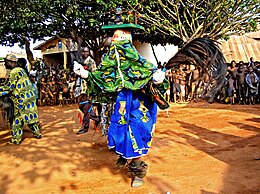
Gelede Masked Festival gallery
[edit]References
[edit]- ^ "World Gazeteer". Archived from the original on 11 January 2013.
- ^ a b c d "Cove". Atlas Monographique des Communes du Benin. Archived from the original on 9 May 2021. Retrieved 5 January 2010.
- ^ "Communes of Benin". Statoids. Archived from the original on 24 March 2012. Retrieved 5 January 2010.
- ^ a b "Cove". www.cove.communedubenin.org. Archived from the original on 5 September 2013. Retrieved 8 January 2009.


