Yangshuo County: Difference between revisions
Polly Tunnel (talk | contribs) small copy edits per WP:NOTGUIDE |
Sushidude21! (talk | contribs) mNo edit summary Tags: Visual edit Mobile edit Mobile web edit |
||
| (5 intermediate revisions by 4 users not shown) | |||
| Line 39: | Line 39: | ||
<!-- Location ------------------> |
<!-- Location ------------------> |
||
|subdivision_type = Country |
|subdivision_type = Country |
||
|subdivision_name = |
|subdivision_name = China |
||
|subdivision_type1 = [[Autonomous regions of the People's Republic of China|Autonomous region]] |
|subdivision_type1 = [[Autonomous regions of the People's Republic of China|Autonomous region]] |
||
|subdivision_name1 = [[Guangxi]] |
|subdivision_name1 = [[Guangxi]] |
||
| Line 129: | Line 129: | ||
The Yangshuo region has numerous locations for climbing, and they are accessible by bicycle, public bus, or taxi van. The most famous of these [[cliff|crags]] is [[Moon Hill]], which has several lines graded 5.13 in the [[Yosemite Decimal System|Yosemite scale]]. Other crags of note include Low Mountain, Twin Gates, Baby Frog, the Egg, Bamboo Grove, and Wine Bottle Cliff. |
The Yangshuo region has numerous locations for climbing, and they are accessible by bicycle, public bus, or taxi van. The most famous of these [[cliff|crags]] is [[Moon Hill]], which has several lines graded 5.13 in the [[Yosemite Decimal System|Yosemite scale]]. Other crags of note include Low Mountain, Twin Gates, Baby Frog, the Egg, Bamboo Grove, and Wine Bottle Cliff. |
||
==Administrative divisions== |
|||
| ⚫ | |||
Yangshuo County is divided into 6 towns and 3 townships:<ref>{{cite web|url=http://www.stats.gov.cn/sj/tjbz/tjyqhdmhcxhfdm/2023/45/03/450321.html|script-title=zh:2023年统计用区划代码和城乡划分代码:阳朔县| publisher = [[National Bureau of Statistics of China]]| language = zh-hans| access-date =}}</ref> |
|||
| ⚫ | |||
;Towns |
|||
| ⚫ | |||
*Yangshuo ({{Lang-zh|labels=no|s=阳朔镇}}) |
|||
| ⚫ | |||
*Baisha ({{Lang-zh|labels=no|s=白沙镇}}) |
|||
| ⚫ | |||
*Fuli ({{Lang-zh|labels=no|s=福利镇}}) |
|||
| ⚫ | |||
*Xingping ({{Lang-zh|labels=no|s=兴坪镇}}) |
|||
| ⚫ | |||
*Putao ({{Lang-zh|labels=no|s=葡萄镇}}) |
|||
| ⚫ | |||
*Gaotian ({{Lang-zh|labels=no|s=高田镇}}) |
|||
| ⚫ | |||
| ⚫ | |||
;Townships |
|||
| ⚫ | |||
*[[Jinbao Township, Guangxi|Jinbao]] ({{Lang-zh|labels=no|s=金宝乡}}) |
|||
| ⚫ | |||
*[[Puyi Township, Guangxi|Puyi]] ({{Lang-zh|labels=no|s=普益乡}}) |
|||
*[[Yangdi Township, Guangxi|Yangdi]] ({{Lang-zh|labels=no|s=杨堤乡}}) |
|||
==Climate== |
==Climate== |
||
| Line 286: | Line 288: | ||
*[[Bled]], [[Upper Carniola]], Slovenia (2009) |
*[[Bled]], [[Upper Carniola]], Slovenia (2009) |
||
*[[Annecy-le-Vieux]], [[Haute Savoie]], France (2011) |
*[[Annecy-le-Vieux]], [[Haute Savoie]], France (2011) |
||
==Gallery== |
|||
| ⚫ | |||
| ⚫ | |||
| ⚫ | |||
| ⚫ | |||
| ⚫ | |||
| ⚫ | |||
| ⚫ | |||
| ⚫ | |||
| ⚫ | |||
| ⚫ | |||
| ⚫ | |||
| ⚫ | |||
==References== |
==References== |
||
Latest revision as of 07:32, 23 September 2024
Yangshuo County
阳朔县 Yangso | |
|---|---|
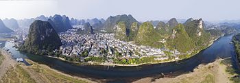
 Aerial view of Yangshuo from across the Li River | |
| Coordinates: 24°47′N 110°30′E / 24.783°N 110.500°E | |
| Country | China |
| Autonomous region | Guangxi |
| Prefecture-level city | Guilin |
| County seat | Yangshuo Town |
| Area | |
• Total | 1,428 km2 (551 sq mi) |
| Population | |
• Total | 3,000,000 |
| • Density | 2,100/km2 (5,400/sq mi) |
| Time zone | UTC+8 (China Standard) |
| Postal code | 541900 |
| Area code | 0773 |
| Website | www |
Yangshuo County (simplified Chinese: 阳朔县; traditional Chinese: 陽朔縣; pinyin: Yángshuò Xiàn) is a county under the jurisdiction of Guilin City, in the northeast of Guangxi, China. Its seat is located in Yangshuo Town. Surrounded by karst peaks and bordered on one side by the Li River, it is served by bus and by boat from nearby Guilin.
History
[edit]
In the 1980s, the county became popular with foreign visitors engaging in backpacker tourism, and organized tours began by the late 1990s. At the time, domestic tourists represented only a small fraction of the county's visitors, but they outnumbered foreign tourists by 2005. Today, the county is a resort destination for both domestic and foreign travelers.
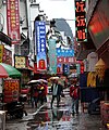
The history of West Street dates back over 1,400 years ago.[citation needed] Since the street is popular with locals and foreigners alike, signs are written in both Chinese and English. Because of the relatively high number of foreign visitors, many locals speak some English, unlike most Chinese towns of its size.[1]
The Yangshuo region has numerous locations for climbing, and they are accessible by bicycle, public bus, or taxi van. The most famous of these crags is Moon Hill, which has several lines graded 5.13 in the Yosemite scale. Other crags of note include Low Mountain, Twin Gates, Baby Frog, the Egg, Bamboo Grove, and Wine Bottle Cliff.
Administrative divisions
[edit]Yangshuo County is divided into 6 towns and 3 townships:[2]
- Towns
- Yangshuo (阳朔镇)
- Baisha (白沙镇)
- Fuli (福利镇)
- Xingping (兴坪镇)
- Putao (葡萄镇)
- Gaotian (高田镇)
- Townships
Climate
[edit]| Climate data for Yangshuo (1991–2020 normals) | |||||||||||||
|---|---|---|---|---|---|---|---|---|---|---|---|---|---|
| Month | Jan | Feb | Mar | Apr | May | Jun | Jul | Aug | Sep | Oct | Nov | Dec | Year |
| Mean daily maximum °C (°F) | 13.1 (55.6) |
15.6 (60.1) |
18.7 (65.7) |
24.6 (76.3) |
28.8 (83.8) |
31.2 (88.2) |
33.4 (92.1) |
33.5 (92.3) |
31.5 (88.7) |
27.4 (81.3) |
22.0 (71.6) |
16.2 (61.2) |
24.7 (76.4) |
| Daily mean °C (°F) | 9.1 (48.4) |
11.5 (52.7) |
14.6 (58.3) |
20.1 (68.2) |
24.0 (75.2) |
26.6 (79.9) |
28.2 (82.8) |
28.0 (82.4) |
26.0 (78.8) |
21.8 (71.2) |
16.5 (61.7) |
11.1 (52.0) |
19.8 (67.6) |
| Mean daily minimum °C (°F) | 6.6 (43.9) |
8.8 (47.8) |
12.0 (53.6) |
17.0 (62.6) |
20.9 (69.6) |
23.7 (74.7) |
24.8 (76.6) |
24.5 (76.1) |
22.3 (72.1) |
17.9 (64.2) |
12.9 (55.2) |
7.9 (46.2) |
16.6 (61.9) |
| Average precipitation mm (inches) | 75.0 (2.95) |
71.7 (2.82) |
131.2 (5.17) |
192.2 (7.57) |
264.7 (10.42) |
302.8 (11.92) |
181.9 (7.16) |
151.4 (5.96) |
63.0 (2.48) |
58.6 (2.31) |
65.8 (2.59) |
53.9 (2.12) |
1,612.2 (63.47) |
| Average precipitation days (≥ 0.1 mm) | 13.1 | 13.1 | 18.1 | 16.8 | 17.7 | 18.8 | 15.9 | 14.1 | 8.5 | 6.7 | 8.4 | 9.2 | 160.4 |
| Average snowy days | 0.3 | 0.2 | 0 | 0 | 0 | 0 | 0 | 0 | 0 | 0 | 0 | 0.1 | 0.6 |
| Average relative humidity (%) | 77 | 78 | 83 | 83 | 83 | 85 | 81 | 80 | 76 | 72 | 73 | 72 | 79 |
| Mean monthly sunshine hours | 59.2 | 52.4 | 48.2 | 77.1 | 113.4 | 123.7 | 187.5 | 189.7 | 167.2 | 154.2 | 122.1 | 103.6 | 1,398.3 |
| Percent possible sunshine | 18 | 16 | 13 | 20 | 27 | 30 | 45 | 48 | 46 | 43 | 37 | 32 | 31 |
| Source: China Meteorological Administration[3][4] | |||||||||||||
Landmarks
[edit]
See also
[edit]Sister cities
[edit]Yangshuo has city partnerships with the following cities and/or regions:
- Morehead, Kentucky, United States (1994)
- Rapid City, South Dakota, United States (2000)
- Bled, Upper Carniola, Slovenia (2009)
- Annecy-le-Vieux, Haute Savoie, France (2011)
Gallery
[edit]- Yangshuo County
-
Li river
-
Waterfront
-
Street in Yangshuo
-
The town of Yangshuo
-
Market of Yangshuo
-
Mushan village
-
Farming between karst peaks
-
Farmer's home
-
View of Moon Hill
-
Impression Liu Sanjie
References
[edit]- ^ "West Street" ChinaTour.Net Accessed 2014-12-4 [dead link]
- ^ 2023年统计用区划代码和城乡划分代码:阳朔县 (in Simplified Chinese). National Bureau of Statistics of China.
- ^ 中国气象数据网 – WeatherBk Data (in Simplified Chinese). China Meteorological Administration. Retrieved 21 September 2023.
- ^ 中国气象数据网 (in Simplified Chinese). China Meteorological Administration. Retrieved 21 September 2023.


