Municipality of Hrpelje-Kozina: Difference between revisions
Appearance
Content deleted Content added
removed Category:Slovenian Littoral; added Category:Municipalities in the Slovenian Littoral using HotCat |
|||
| (37 intermediate revisions by 22 users not shown) | |||
| Line 1: | Line 1: | ||
{{Short description|Municipality of Slovenia}} |
|||
{{Infobox settlement |
{{Infobox settlement |
||
| name = Municipality of |
| name = Municipality of Hrpelje-Kozina |
||
| native_name = Občina Hrpelje - Kozina |
| native_name = ''Občina Hrpelje - Kozina'' |
||
| native_name_lang = sl<!-- ISO 639-2 code e.g. "fr" for French. If more than one, use {{lang}} instead --> |
| native_name_lang = sl<!-- ISO 639-2 code e.g. "fr" for French. If more than one, use {{lang}} instead --> |
||
| settlement_type = |
| settlement_type = [[Municipalities of Slovenia|Municipality]] |
||
| image_skyline = |
| image_skyline = Hrpelje SLO.JPG |
||
| image_alt = |
| image_alt = |
||
| image_caption = |
| image_caption = Hrpelje |
||
| image_shield = |
| image_shield = Coat of Arms of Hrpelje-Kozina.png |
||
| image_flag = |
| image_flag = |
||
| |
| shield_size = 120x80px |
||
| nickname = |
| nickname = |
||
| motto = |
| motto = |
||
| image_map = Karte Hrpelje si.png |
| image_map = Karte Hrpelje si.png |
||
| map_alt = |
| map_alt = |
||
| map_caption = Location of the Municipality of |
| map_caption = Location of the Municipality of Hrpelje-Kozina in Slovenia |
||
| pushpin_map = |
| pushpin_map = |
||
| pushpin_label_position = |
| pushpin_label_position = |
||
| pushpin_map_alt = |
| pushpin_map_alt = |
||
| pushpin_map_caption = |
| pushpin_map_caption = |
||
| coordinates = {{coord|45|35|N|13|59|E|region:SI_type:city|display=inline,title}} |
|||
| latd = 45|latm = 35|lats = |latNS = N |
|||
| longd = 13|longm = 59|longs = |longEW = E |
|||
| coor_pinpoint = |
| coor_pinpoint = |
||
| coordinates_type = region:SI_type:city |
|||
| coordinates_display = title |
|||
| coordinates_footnotes = |
| coordinates_footnotes = |
||
| coordinates_region = SI |
|||
| subdivision_type = [[List of sovereign states|Country]] |
| subdivision_type = [[List of sovereign states|Country]] |
||
| subdivision_name = {{flag|Slovenia}} |
| subdivision_name = {{flag|Slovenia}} |
||
| Line 35: | Line 32: | ||
| government_footnotes = |
| government_footnotes = |
||
| leader_party = |
| leader_party = |
||
| leader_title = |
| leader_title = Mayor |
||
| leader_name = |
| leader_name = Saša Likavec Svetelšek |
||
| unit_pref = Metric |
| unit_pref = Metric |
||
| area_footnotes = |
| area_footnotes = |
||
| Line 59: | Line 56: | ||
| area_code = |
| area_code = |
||
| iso_code = |
| iso_code = |
||
| website = |
| website = {{Official URL}} |
||
| footnotes = |
| footnotes = |
||
}} |
}} |
||
The '''Municipality of |
The '''Municipality of Hrpelje-Kozina''' ({{IPA|sl|xəɾˈpeːljɛ kɔˈziːna|pron}}; {{langx|sl|Občina Hrpelje - Kozina}}) is a municipality in the [[Slovenian Littoral|Littoral]] region of [[Slovenia]].<ref>[http://www.hrpelje-kozina.si/cms/index.php Hrpelje-Kozina municipal site] {{webarchive|url=https://web.archive.org/web/20081218113855/http://www.hrpelje-kozina.si/cms/index.php |date=2008-12-18 }}</ref> Its seat is the village of [[Hrpelje]]. |
||
A major [[border crossing]] to Italy is located in the municipality at the village of [[Krvavi Potok]]. It connects to |
A major [[border crossing]] to Italy is located in the municipality at the village of [[Krvavi Potok]]. It connects to Pesek in the Municipality of [[San Dorligo della Valle]] (Dolina) near [[Trieste]] on the Italian side. It borders [[Italy]] and [[Croatia]]. |
||
==Settlements== |
|||
In addition to the municipal seat of Hrpelje, the municipality also includes the following settlements: |
|||
{{Div col|colwidth=14em}} |
|||
# [[Artviže]] |
|||
# [[Bač pri Materiji]] |
|||
| ⚫ | |||
| ⚫ | |||
# [[Brezovo Brdo]] |
|||
# [[Golac]] |
|||
# [[Gradišče pri Materiji]] |
|||
# [[Gradišica]] |
|||
# [[Hotična]] |
|||
| ⚫ | |||
# [[Klanec pri Kozini]] |
|||
# [[Kovčice]] |
|||
| ⚫ | |||
# [[Krvavi Potok]] |
|||
# [[Markovščina]] |
|||
# [[Materija]] |
|||
# [[Mihele]] |
|||
# [[Mrše]] |
|||
# [[Nasirec]] |
|||
| ⚫ | |||
# [[Ocizla]] |
|||
# [[Odolina]] |
|||
# [[Orehek pri Materiji]] |
|||
| ⚫ | |||
# [[Petrinje]] |
|||
# [[Poljane pri Podgradu]] |
|||
# [[Povžane]] |
|||
# [[Prešnica]] |
|||
# [[Ritomeče]] |
|||
# [[Rodik]] |
|||
# [[Rožice]] |
|||
# [[Skadanščina]] |
|||
| ⚫ | |||
| ⚫ | |||
| ⚫ | |||
# [[Tublje pri Hrpeljah]] |
|||
# [[Velike Loče]] |
|||
| ⚫ | |||
{{Div col end}} |
|||
==References== |
==References== |
||
| Line 70: | Line 110: | ||
==External links== |
==External links== |
||
*{{commons category-inline}} |
|||
*[http://www.geopedia.si/Geopedia_en.html#L5567_F10131146_vF_b4_x417036.5_y52405.5_s15 Hrpelje–Kozina on Geopedia] |
|||
*[https://www.geopedia.world/#T12_L362_F2463:78_x1558494.959939313_y5710574.585044542_s12_b2345 Municipality of Hrpelje-Kozina on Geopedia] |
|||
{{Geographic location |
|||
{{Hrpelje–Kozina}} |
|||
| ⚫ | |||
| N = [[Municipality of Sežana|Sežana]] / [[Municipality of Divača|Divača]] |
|||
| E = [[Municipality of Ilirska Bistrica|Ilirska Bistrica]] |
|||
| SE = {{flagicon|Croatia}} [[Matulji]] ([[Primorje-Gorski Kotar County]]) |
|||
| S = {{flagicon|Croatia}} [[Lanišće]] ([[Istria County]]) |
|||
| W = [[City Municipality of Koper|Koper]] |
|||
| NW = {{flagicon|Italy}} [[San Dorligo della Valle]] ([[Friuli-Venezia Giulia]]) |
|||
}} |
|||
{{Hrpelje-Kozina}} |
|||
{{Municipalities of Slovenia}} |
{{Municipalities of Slovenia}} |
||
| ⚫ | |||
{{Authority control}} |
|||
| ⚫ | |||
[[Category:Municipalities in the Slovenian Littoral|Hrpelje–Kozina]] |
|||
{{DEFAULTSORT:Municipality of Hrpelje-Kozina}} |
|||
| ⚫ | |||
| ⚫ | |||
[[Category:1994 establishments in Slovenia]] |
[[Category:1994 establishments in Slovenia]] |
||
{{HrpeljeKozina-geo-stub}} |
{{HrpeljeKozina-geo-stub}} |
||
| ⚫ | |||
| ⚫ | |||
| ⚫ | |||
| ⚫ | |||
[[it:Erpelle-Cosina]] |
|||
| ⚫ | |||
[[ja:フルペリェ=コジナ]] |
|||
| ⚫ | |||
| ⚫ | |||
| ⚫ | |||
| ⚫ | |||
[[sr:Општина Хрпеље - Козина]] |
|||
| ⚫ | |||
[[uk:Хрпелє-Козіна]] |
|||
| ⚫ | |||
Latest revision as of 23:21, 6 November 2024
Municipality of Hrpelje-Kozina
Občina Hrpelje - Kozina | |
|---|---|
 Hrpelje | |
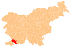
 Location of the Municipality of Hrpelje-Kozina in Slovenia | |
| Coordinates: 45°35′N 13°59′E / 45.583°N 13.983°E | |
| Country | |
| Government | |
| • Mayor | Saša Likavec Svetelšek |
| Area | |
• Total | 192.2 km2 (74.2 sq mi) |
| Population (2002)[1] | |
• Total | 4,038 |
| • Density | 21/km2 (54/sq mi) |
| Time zone | UTC+01 (CET) |
| • Summer (DST) | UTC+02 (CEST) |
| Website | www |
The Municipality of Hrpelje-Kozina (pronounced [xəɾˈpeːljɛ kɔˈziːna]; Slovene: Občina Hrpelje - Kozina) is a municipality in the Littoral region of Slovenia.[2] Its seat is the village of Hrpelje.
A major border crossing to Italy is located in the municipality at the village of Krvavi Potok. It connects to Pesek in the Municipality of San Dorligo della Valle (Dolina) near Trieste on the Italian side. It borders Italy and Croatia.
Settlements
[edit]In addition to the municipal seat of Hrpelje, the municipality also includes the following settlements:
- Artviže
- Bač pri Materiji
- Beka
- Brezovica
- Brezovo Brdo
- Golac
- Gradišče pri Materiji
- Gradišica
- Hotična
- Javorje
- Klanec pri Kozini
- Kovčice
- Kozina
- Krvavi Potok
- Markovščina
- Materija
- Mihele
- Mrše
- Nasirec
- Obrov
- Ocizla
- Odolina
- Orehek pri Materiji
- Ostrovica
- Petrinje
- Poljane pri Podgradu
- Povžane
- Prešnica
- Ritomeče
- Rodik
- Rožice
- Skadanščina
- Slivje
- Slope
- Tatre
- Tublje pri Hrpeljah
- Velike Loče
- Vrhpolje
References
[edit]External links
[edit] Media related to Municipality of Hrpelje-Kozina at Wikimedia Commons
- Municipality of Hrpelje-Kozina on Geopedia


