Municipality of Dobrovnik
Appearance
Municipality of Dobrovnik
Občina Dobrovnik Dobronak község | |
|---|---|
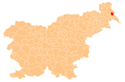
 Location of the Municipality of Dobrovnik in Slovenia | |
| Coordinates: 46°39′N 16°21′E / 46.650°N 16.350°E | |
| Country | |
| Government | |
| • Mayor | Marjan Kardinar (LDS) |
| Area | |
• Total | 31.1 km2 (12.0 sq mi) |
| Population (2008)[1] | |
• Total | 1,332 |
| • Density | 43/km2 (110/sq mi) |
| Time zone | UTC+01 (CET) |
| • Summer (DST) | UTC+02 (CEST) |
| Website | www |
The Municipality of Dobrovnik (Slovene: Občina Dobrovnik [ˈóːptʃina dɔˈbɾɔ́ːwnik]; Hungarian: Dobronak község [ˈdobronɒk ˈkøʃʃeːɡ]) is a municipality in Slovenia. The seat of the municipality is Dobrovnik (Hungarian: Dobronak). It is located in the Prekmurje region. It has a significant Hungarian ethnic community that outnumbers the Slovenes. Dobrovnik is one of the two municipalities in Slovenia where ethnic Slovenes form a minority of the population, the other being Hodoš (Hungarian: Hodos).
Settlements
[edit]
In addition to the municipal seat of Dobrovnik, the municipality also includes the settlements of Strehovci and Žitkovci.
Demographics
[edit]- Population by native language, 2002 census[2]
| Hungarian | 675 (51.6%) |
| Slovene | 551 (44.6%) |
| Others and unknown | 71 (5.43%) |
| Total | 1,307 |
References
[edit]External links
[edit] Media related to Municipality of Dobrovnik at Wikimedia Commons
- Municipality of Dobrovnik on Geopedia
- Dobrovnik municipal site


