Municipality of Lukovica: Difference between revisions
Appearance
Content deleted Content added
m Task 18 (cosmetic): eval 2 templates: hyphenate params (1×); |
|||
| (9 intermediate revisions by 8 users not shown) | |||
| Line 1: | Line 1: | ||
| ⚫ | |||
{{otheruses|Lukovica (disambiguation)}} |
|||
{{Redirect|Lukovica}} |
|||
| ⚫ | |||
{{Infobox settlement |
{{Infobox settlement |
||
| name = Municipality of Lukovica |
| name = Municipality of Lukovica |
||
| Line 42: | Line 42: | ||
| elevation_footnotes = |
| elevation_footnotes = |
||
| elevation_m = |
| elevation_m = |
||
| population_footnotes = <ref> |
| population_footnotes = <ref>{{cite web | url=https://pxweb.stat.si/SiStatData/pxweb/en/Data/Data/05F3005S.px/ | title=Population, households and families by MUNICIPALITIES, YEAR and MEASURES }}</ref> |
||
| population_total = |
| population_total = 5888 |
||
| population_as_of = |
| population_as_of = 2021 |
||
| population_density_km2 = auto |
| population_density_km2 = auto |
||
| population_demonym = |
| population_demonym = |
||
| Line 60: | Line 60: | ||
| footnotes = |
| footnotes = |
||
}} |
}} |
||
The '''Municipality of Lukovica''' ({{IPA |
The '''Municipality of Lukovica''' ({{IPA|sl|ˈluːkɔʋitsa|pron}}; {{langx|sl|Občina Lukovica}}) is a municipality in the eastern part of the [[Upper Carniola]] region in [[Slovenia]]. The seat of the municipality is [[Lukovica pri Domžalah]]. It lies on the main road from [[Ljubljana]] to [[Celje]] and has been an independent municipality since 1994.<ref>{{Cite web |url=http://www.lukovica.si/prvastran/default-en.asp |title=Lukovica municipal site |access-date=2008-12-30 |archive-url=https://web.archive.org/web/20060329000833/http://www.lukovica.si/prvastran/default-en.asp |archive-date=2006-03-29 |url-status=dead }}</ref><ref>{{cite book |title=Vzpostavitev lokalne samouprave v Republiki Sloveniji v številkah |date=2007 |publisher=Statistični urad Republike Slovenije |location=Ljubljana |page=74|url=https://www.stat.si/StatWeb/File/DocSysFile/1290 |access-date=February 27, 2020}}</ref> |
||
==Settlements== |
==Settlements== |
||
| Line 136: | Line 136: | ||
==External links== |
==External links== |
||
*{{ |
*{{Commons category-inline}} |
||
*[ |
*[https://www.geopedia.world/#T12_L362_F2463:90_x1644500.2308823555_y5808444.419700288_s12_b2345 Municipality of Lukovica on Geopedia] |
||
{{Geographic location |
{{Geographic location |
||
| Line 148: | Line 148: | ||
{{Lukovica}} |
{{Lukovica}} |
||
{{Municipalities of Slovenia}} |
{{Municipalities of Slovenia}} |
||
{{Authority control}} |
|||
[[Category:Municipality of Lukovica| ]] |
[[Category:Municipality of Lukovica| ]] |
||
[[Category:Municipalities of Slovenia|Lukovica]] |
[[Category:Municipalities of Slovenia|Lukovica]] |
||
[[Category:1994 establishments in Slovenia]] |
[[Category:1994 establishments in Slovenia]] |
||
{{Lukovica-geo-stub}} |
|||
Latest revision as of 05:39, 7 November 2024
Municipality of Lukovica
Občina Lukovica | |
|---|---|
 | |
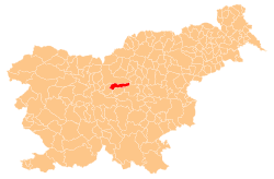
 Location of the Municipality of Lukovica in Slovenia | |
| Coordinates: 46°10′N 14°42′E / 46.167°N 14.700°E | |
| Country | |
| Government | |
| • Mayor | Olga Vrankar |
| Area | |
• Total | 74.9 km2 (28.9 sq mi) |
| Population (2021)[1] | |
• Total | 5,888 |
| • Density | 79/km2 (200/sq mi) |
| Time zone | UTC+01 (CET) |
| • Summer (DST) | UTC+02 (CEST) |
| Website | www |
The Municipality of Lukovica (pronounced [ˈluːkɔʋitsa]; Slovene: Občina Lukovica) is a municipality in the eastern part of the Upper Carniola region in Slovenia. The seat of the municipality is Lukovica pri Domžalah. It lies on the main road from Ljubljana to Celje and has been an independent municipality since 1994.[2][3]
Settlements
[edit]In addition to the municipal seat of Lukovica pri Domžalah, the municipality also includes the following settlements:
- Blagovica
- Brdo pri Lukovici
- Brezovica pri Zlatem Polju
- Bršlenovica
- Čeplje
- Češnjice
- Dupeljne
- Gabrje pod Špilkom
- Golčaj
- Gorenje
- Gradišče pri Lukovici
- Hribi
- Imovica
- Javorje pri Blagovici
- Jelša
- Kompolje
- Koreno
- Korpe
- Krajno Brdo
- Krašnja
- Lipa
- Log
- Mala Lašna
- Mali Jelnik
- Obrše
- Podgora pri Zlatem Polju
- Podmilj
- Podsmrečje
- Poljane nad Blagovico
- Preserje pri Lukovici
- Preserje pri Zlatem Polju
- Prevalje
- Prevoje
- Prevoje pri Šentvidu
- Prilesje
- Prvine
- Rafolče
- Selce
- Šentožbolt
- Šentvid pri Lukovici
- Spodnje Koseze
- Spodnje Loke
- Spodnje Prapreče
- Spodnji Petelinjek
- Straža
- Suša
- Trnjava
- Trnovče
- Trojane
- Učak
- V Zideh
- Veliki Jelnik
- Videm pri Lukovici
- Vošce
- Vranke
- Vrba
- Vrh nad Krašnjo
- Vrhovlje
- Zavrh pri Trojanah
- Zgornje Loke
- Zgornje Prapreče
- Zgornji Petelinjek
- Žirovše
- Zlatenek
- Zlato Polje
References
[edit]- ^ "Population, households and families by MUNICIPALITIES, YEAR and MEASURES".
- ^ "Lukovica municipal site". Archived from the original on 2006-03-29. Retrieved 2008-12-30.
- ^ Vzpostavitev lokalne samouprave v Republiki Sloveniji v številkah. Ljubljana: Statistični urad Republike Slovenije. 2007. p. 74. Retrieved February 27, 2020.
External links
[edit] Media related to Municipality of Lukovica at Wikimedia Commons
- Municipality of Lukovica on Geopedia


