Yuli, Hualien: Difference between revisions
Appearance
Content deleted Content added
m →Administrative divisions: typo |
|||
| (35 intermediate revisions by 22 users not shown) | |||
| Line 1: | Line 1: | ||
{{Expand Chinese|date=January 2022|topic=geo}} |
|||
{{Infobox Settlement |
|||
{{Infobox settlement |
|||
<!--See the Table at Infobox Settlement for all fields and descriptions of usage--> |
|||
<!-- See Template:Infobox settlement for additional fields and descriptions --> |
|||
<!-- Basic info ----------------> |
|||
|official_name = Yuli Township |
<!-- Basic info ---------------->| official_name = Yuli Township |
||
| |
| native_name = [[Hanzi]]: {{lang|zh-TW|玉里鎮}}<br /> |
||
Japanese: Tamazato ([[Kanji]]: {{lang|ja|玉里}} [{{lang|ja|たまざと}}])<br /> |
|||
|native_name = 玉里鎮 |
|||
{{langx|ami|Posko}}; [[Bunun language|Bunun]]: {{lang|bnn|Pusqu}} (Hanzi transliterated by 1917: {{lang|zh|璞石閣}}) |
|||
|Capital = |
|||
| |
| capital = |
||
| nickname = |
|||
|settlement_type = <!--For Town or Village (Leave blank for the default City)--> |
|||
| settlement_type = [[Township (Taiwan)|Urban township]]<!--For Town or Village (Leave blank for the default City)--> |
|||
|motto = |
|||
<!-- images and maps -----------> |
| motto = <!-- images and maps -----------> |
||
|image_skyline = Yuli |
| image_skyline = File:Yuli Town view.JPG |
||
|imagesize = 250px |
| imagesize = 250px |
||
|image_caption = |
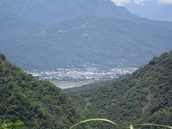
| image_caption = Aerial view of Yuli Township |
||
|image_flag = |
| image_flag = |
||
|flag_size = |
| flag_size = |
||
|image_seal = |
| image_seal = |
||
|seal_size = |
| seal_size = |
||
|image_shield = |
| image_shield = |
||
|shield_size = |
| shield_size = |
||
|city_logo = |
| city_logo = |
||
|citylogo_size = |
| citylogo_size = |
||
|image_map = Yuli_HL.svg |
| image_map = Yuli_HL.svg |
||
|mapsize = |
| mapsize = |
||
|map_caption = |
| map_caption = |
||
|image_map1 = |
| image_map1 = |
||
|mapsize1 = |
| mapsize1 = |
||
|map_caption1 = |
| map_caption1 = |
||
|image_dot_map = |
| image_dot_map = |
||
|dot_mapsize = |
| dot_mapsize = |
||
|dot_map_caption = |
| dot_map_caption = |
||
|dot_x |
| dot_x = |
||
| |
| dot_y = |
||
| pushpin_map = Taiwan |
|||
|pushpin_label_position = |
|||
| pushpin_label_position = |
|||
|pushpin_map_caption = |
|||
| |
| pushpin_map_caption = |
||
<!-- Location ------------------> |
| pushpin_mapsize = <!-- Location ------------------> |
||
|subdivision_type = Country |
| subdivision_type = Country |
||
|subdivision_name = [[Taiwan]] |
| subdivision_name = [[Taiwan|Republic of China (Taiwan)]] |
||
|subdivision_type1 = Region |
| subdivision_type1 = [[Regions of Taiwan|Region]] |
||
|subdivision_name1 = Eastern Taiwan |
| subdivision_name1 = Eastern Taiwan |
||
|subdivision_type2 = |
| subdivision_type2 = [[County (Taiwan)|County]] |
||
|subdivision_name2 = |
| subdivision_name2 = [[Hualien County]]<!-- Smaller parts (e.g. boroughs of a city) and seat of government --> |
||
| seat_type = |
|||
<!-- Smaller parts (e.g. boroughs of a city) and seat of government --> |
|||
| |
| seat = |
||
| |
| parts_type = |
||
| parts_style = <!-- =list (for list), coll (for collapsed list), para (for paragraph format) Default is list if up to 5 items, coll if more than 5--> |
|||
|parts_type = |
|||
| |
| parts = <!-- parts text, or header for parts list --> |
||
| |
| p1 = |
||
| |
| p2 = <!-- etc. up to p50: for separate parts to be listed--> |
||
<!-- Politics ----------------->| government_footnotes = |
|||
|p2 = <!-- etc. up to p50: for separate parts to be listed--> |
|||
| government_type = Township council |
|||
<!-- Politics -----------------> |
|||
| leader_title = [[Mayor]] |
|||
|government_footnotes = |
|||
| leader_name = |
|||
|government_type = Urban Township |
|||
| leader_title1 = <!-- for places with, say, both a mayor and a city manager --> |
|||
|leader_title = Mayor |
|||
| |
| leader_name1 = |
||
| |
| leader_title2 = |
||
| |
| leader_name2 = |
||
| |
| established_title = <!-- Settled --> |
||
| |
| established_date = |
||
| |
| established_title2 = <!-- Incorporated (town) --> |
||
| |
| established_date2 = |
||
| |
| established_title3 = <!-- Incorporated (city) --> |
||
| established_date3 = <!-- Area ---------------------> |
|||
|established_date2 = |
|||
| area_magnitude = |
|||
|established_title3 = <!-- Incorporated (city) --> |
|||
| unit_pref = <!--Enter: Imperial, if Imperial (metric) is desired--> |
|||
|established_date3 = |
|||
| area_footnotes = |
|||
<!-- Area ---------------------> |
|||
| area_total_km2 = 252.3719<!-- ALL fields dealing with a measurements are subject to automatic unit conversion--> |
|||
|area_magnitude = |
|||
| |
| area_land_km2 = <!--See table @ Template:Infobox Settlement for details on automatic unit conversion--> |
||
| |
| area_water_km2 = |
||
| area_total_sq_mi = |
|||
|area_total_km2 = 252.3719<!-- ALL fields dealing with a measurements are subject to automatic unit conversion--> |
|||
| area_land_sq_mi = |
|||
|area_land_km2 = <!--See table @ Template:Infobox Settlement for details on automatic unit conversion--> |
|||
| |
| area_water_sq_mi = |
||
| |
| area_water_percent = |
||
| |
| area_urban_km2 = |
||
| |
| area_urban_sq_mi = |
||
| |
| area_metro_km2 = |
||
| |
| area_metro_sq_mi = |
||
| |
| area_blank1_title = |
||
| |
| area_blank1_km2 = |
||
| area_blank1_sq_mi = <!-- Population -----------------------> |
|||
|area_metro_sq_mi = |
|||
| |
| population_as_of = March 2023 |
||
| |
| population_footnotes = |
||
| |
| population_note = |
||
| population_total = 22305 |
|||
<!-- Population -----------------------> |
|||
| |
| population_density_km2 = |
||
| |
| population_density_sq_mi = |
||
| |
| population_metro = |
||
| population_density_metro_km2 = |
|||
|population_total = 25,396 |
|||
| population_density_metro_sq_mi = |
|||
|population_density_km2 = |
|||
| |
| population_urban = |
||
| population_density_urban_km2 = |
|||
|population_metro = |
|||
| population_density_urban_sq_mi = |
|||
|population_density_metro_km2 = |
|||
| population_density_blank1_km2 = |
|||
|population_density_metro_sq_mi = |
|||
| population_density_blank1_sq_mi = <!-- General information ---------------> |
|||
|population_urban = |
|||
| timezone = [[Time in Taiwan|CST]] |
|||
|population_density_urban_km2 = |
|||
| utc_offset = +8 |
|||
|population_density_urban_sq_mi = |
|||
| |
| timezone_DST = |
||
| |
| utc_offset_DST = |
||
| coordinates = {{Coord|23|23|15|N|121|22|35|E|region:TW_type:city|display=inline,title}} |
|||
|population_density_blank1_km2 = |
|||
| elevation_footnotes = <!--for references: use <ref> </ref> tags--> |
|||
|population_density_blank1_sq_mi = |
|||
| elevation_m = |
|||
<!-- General information ---------------> |
|||
| |
| elevation_ft = <!-- Area/postal codes & others --------> |
||
| |
| postal_code_type = Postal code |
||
| |
| postal_code = 981 |
||
| |
| area_code = |
||
| blank_name = Subdivision |
|||
|latd = 23 |latm = 23 |lats = 15 |latNS= N |
|||
| blank_info = 15 villages |
|||
|longd=121 |longm= 22 |longs= 35 |longEW= E |
|||
| blank1_name = |
|||
|coordinates_type = region:TW_type:city |
|||
| blank1_info = |
|||
|coordinates_display = display=inline,title |
|||
| website = [https://web.archive.org/web/20140306102648/http://www.hlyl.gov.tw/hlylweb/hlyl_en/ HLYL.gov.tw] |
|||
|elevation_footnotes = <!--for references: use <ref> </ref> tags--> |
|||
| |
| footnotes = |
||
| |
| name = |
||
<!-- Area/postal codes & others --------> |
|||
|postal_code_type = Post code |
|||
|postal_code = 981 |
|||
|area_code = |
|||
|blank_name = Subdivision |
|||
|blank_info = 15 Villages |
|||
|blank1_name = |
|||
|blank1_info = |
|||
|website = [https://web.archive.org/web/20140306102648/http://www.hlyl.gov.tw/hlylweb/hlyl_en/ www.hlyl.gov.tw] |
|||
|footnotes = |
|||
}} |
}} |
||
[[File:Yuli |
[[File:Yuli Roundabout 20141010.jpg|thumb|Downtown Yuli]] |
||
[[File:Yuli Township Office, Hualien County 20141010.jpg|thumb|Yuli Township Office]] |
|||
'''Yuli Township''' ({{zh|c=玉里鎮|p=Yùlǐ Zhèn|poj=Gio̍k-lí}}) is an [[Township (Taiwan)|urban township]] located in central [[ |
'''Yuli Township''' ({{zh|c=玉里鎮|p=Yùlǐ Zhèn|poj=Gio̍k-lí-tìn}}; Japanese: Tamazato [ [[Kanji]]: {{lang|ja|玉里}} [{{lang|ja|たまざと}}] ]), {{langx|ami|Posko}}, [[Bunun language|Bunun]]: {{lang|bnn|Pusqu}} (Hanzi transliterated by 1917: {{lang|zh|璞石閣}}), is an [[Township (Taiwan)|urban township]] located in central [[Huadong Valley]], and also the southern administrative center of [[Hualien County]], [[Taiwan]]. It has a population of 22,305 inhabitants and 15 villages.<ref>{{cite web|url=http://www.hlyl.gov.tw/hlylweb/hlyl_en/3.htm |title=YULI Township Government, Hualien |access-date=February 17, 2014 |url-status=dead |archive-url=https://web.archive.org/web/20140306100849/http://www.hlyl.gov.tw/hlylweb/hlyl_en/3.htm |archive-date=March 6, 2014 }}</ref> |
||
==Geography== |
==Geography== |
||
[[File:Txu-pclmaps-oclc-6550512-tamazato-2317-ii.jpg|left|thumb|Map of Yuli (labeled as TAMAZATO) and surrounding areas (1944)]] |
|||
The township is located at the [[Huatung Valley]]. |
|||
[[File:Txu-oclc-6557994-index-453.jpg|left|thumb|Map including Yuli (labeled as Yü-li (Tamazato) {{lang|zh-tw|玉里}}) (1951)]] |
|||
The township is located in the [[Huadong Valley]]. |
|||
==Administrative divisions== |
==Administrative divisions== |
||
The township comprises 15 villages: Chunri, Dayu, Dewu, Guanyin, Guowu, Lege, Qimo, Sanmin, Songpu, Taichang, Tungfeng, Yongchang, Yuancheng, Zhangliang and Zhongcheng. |
The township comprises 15 villages: Chunri, Dayu, Dewu, Guanyin, Guowu, Lege, Qimo, Sanmin, Songpu, Taichang, Tungfeng, Yongchang, Yuancheng, Zhangliang, and Zhongcheng. |
||
==Tourist attractions== |
==Tourist attractions== |
||
{{travel guide|section|date=January 2022}} |
|||
* [[Antong Hot Springs]] |
* [[Antong Hot Springs]] |
||
* [[Dongfeng Leisure Farm]] |
* [[Dongfeng Leisure Farm]] |
||
| Line 141: | Line 136: | ||
* [[Xietian Temple]] |
* [[Xietian Temple]] |
||
* [[Yucyuan Temple]] |
* [[Yucyuan Temple]] |
||
* [[Yuli Jinja]] |
|||
* [[Yushan National Park]]<ref>http://www.erv-nsa.gov.tw/pda/Article.aspx?Lang=2&SNo=03000457</ref> |
|||
* [[Walami Trail]] |
|||
* [[Yushan National Park]]<ref>{{cite web |url=http://www.erv-nsa.gov.tw/pda/Article.aspx?Lang=2&SNo=03000457 |title=East Rift Valley National Scenic Area::PDA |website=www.erv-nsa.gov.tw |access-date=15 January 2022 |archive-url=https://web.archive.org/web/20131029210500/http://www.erv-nsa.gov.tw/pda/Article.aspx?Lang=2&SNo=03000457 |archive-date=29 October 2013 |url-status=dead}}</ref> |
|||
==Transportation== |
==Transportation== |
||
[[File:TRA Yuli Station |
[[File:TRA Yuli Station 3.jpg|thumb|Yuli Rail Station]] |
||
===Railway=== |
|||
* [[Provincial Highway No. 9 (Taiwan)|Provincial Highway No.9]] (Hualien-Taitung Highway) |
|||
[[Taiwan Railways Administration|TRA]] ([[Taitung line]]) |
|||
* [[Provincial Highway No. 30 (Taiwan)|Provincial Highway No.30]] (Yuli-Chengbin Highway) |
|||
* |
*[[Yuli railway station|Yuli Station]] |
||
*[[Sanmin railway station|Sanmin Station]] |
|||
===Road=== |
|||
* [[Provincial Highway 9 (Taiwan)|Provincial Highway 9]] (Hualien-Taitung Highway) |
|||
* [[Provincial Highway 30 (Taiwan)|Provincial Highway 30]] (Yuli-Chengbin Highway) |
|||
* County Road No.193 |
* County Road No.193 |
||
===Bus=== |
|||
* Hualien Bus Company |
* Hualien Bus Company |
||
==Notable natives== |
|||
* [[Evonne Hsieh]], actress |
|||
* [[Umin Boya]], writer, director and actor |
|||
* [[Wu Maw-kuen]], [[Ministry of Education (Taiwan)|Minister of Education]] (2018) |
|||
{{commons category|Yuli Township, Hualien County}} |
{{commons category|Yuli Township, Hualien County}} |
||
| Line 158: | Line 167: | ||
== External links == |
== External links == |
||
{{Wikivoyage|Yuli}} |
|||
* [http://www.hlyl.gov.tw Office of Yu Li Township] (Chinese) |
* [http://www.hlyl.gov.tw Office of Yu Li Township] (Chinese) |
||
| Line 163: | Line 174: | ||
{{Townships in Taiwan}} |
{{Townships in Taiwan}} |
||
{{Taiwanese aboriginal areas}} |
{{Taiwanese aboriginal areas}} |
||
{{Taiwan-geo-stub}} |
|||
[[Category:Townships in Hualien County]] |
[[Category:Townships in Hualien County]] |
||
{{Taiwan-geo-stub}} |
|||
Latest revision as of 21:29, 8 November 2024
You can help expand this article with text translated from the corresponding article in Chinese. (January 2022) Click [show] for important translation instructions.
|
Yuli Township
| |
|---|---|
 Aerial view of Yuli Township | |
 | |
| Coordinates: 23°23′15″N 121°22′35″E / 23.38750°N 121.37639°E | |
| Country | Republic of China (Taiwan) |
| Region | Eastern Taiwan |
| County | Hualien County |
| Government | |
| • Type | Township council |
| Area | |
• Total | 252.3719 km2 (97.4413 sq mi) |
| Population (March 2023) | |
• Total | 22,305 |
| Time zone | UTC+8 (CST) |
| Postal code | 981 |
| Subdivision | 15 villages |
| Website | HLYL.gov.tw |


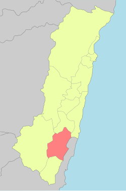
Yuli Township (Chinese: 玉里鎮; pinyin: Yùlǐ Zhèn; Pe̍h-ōe-jī: Gio̍k-lí-tìn; Japanese: Tamazato [ Kanji: 玉里 [たまざと] ]), Amis: Posko, Bunun: Pusqu (Hanzi transliterated by 1917: 璞石閣), is an urban township located in central Huadong Valley, and also the southern administrative center of Hualien County, Taiwan. It has a population of 22,305 inhabitants and 15 villages.[1]
Geography
[edit]

The township is located in the Huadong Valley.
Administrative divisions
[edit]The township comprises 15 villages: Chunri, Dayu, Dewu, Guanyin, Guowu, Lege, Qimo, Sanmin, Songpu, Taichang, Tungfeng, Yongchang, Yuancheng, Zhangliang, and Zhongcheng.
Tourist attractions
[edit]This section is written like a travel guide. (January 2022) |
- Antong Hot Springs
- Dongfeng Leisure Farm
- Mount Chihke
- Teifen Waterfalls
- Xietian Temple
- Yucyuan Temple
- Yuli Jinja
- Walami Trail
- Yushan National Park[2]
Transportation
[edit]
Railway
[edit]Road
[edit]- Provincial Highway 9 (Hualien-Taitung Highway)
- Provincial Highway 30 (Yuli-Chengbin Highway)
- County Road No.193
Bus
[edit]- Hualien Bus Company
Notable natives
[edit]- Evonne Hsieh, actress
- Umin Boya, writer, director and actor
- Wu Maw-kuen, Minister of Education (2018)
Wikimedia Commons has media related to Yuli Township, Hualien County.
References
[edit]- ^ "YULI Township Government, Hualien". Archived from the original on March 6, 2014. Retrieved February 17, 2014.
- ^ "East Rift Valley National Scenic Area::PDA". www.erv-nsa.gov.tw. Archived from the original on 29 October 2013. Retrieved 15 January 2022.
External links
[edit]Wikivoyage has a travel guide for Yuli.
- Office of Yu Li Township (Chinese)


