Ghioroiu: Difference between revisions
Appearance
Content deleted Content added
Adding geodata: {{coord|44|42|N|23|50|E|display=title|region:RO_type:city_source:GNS-enwiki}} |
river |
||
| (26 intermediate revisions by 15 users not shown) | |||
| Line 1: | Line 1: | ||
{{Infobox Romanian subdivision |
|||
| ⚫ | |||
|type = commune |
|||
|name = Ghioroiu |
|||
|county = Vâlcea |
|||
|image_flag = |
|||
|image_shield = ROU VL Ghioroiu CoA.jpg |
|||
|image_skyline = Mierea VL.bis.NE.jpg |
|||
|image_caption = The Saint Voivodes Church, Mierea |
|||
|image_location = |
|||
|image_map = Ghioroiu en distrikto Vâlcea.png |
|||
|map_caption = Location in Vâlcea County |
|||
|leader_name = Iosiv Predescu<ref>{{cite web |url=https://prezenta.roaep.ro/locale27092020/romania-pv-final |title=Results of the 2020 local elections |publisher=Central Electoral Bureau |access-date=9 June 2021 |df=dmy-all}}</ref> |
|||
|term = 2020–2024 |
|||
|leader_party = PNL |
|||
|coordinates = {{coord|44|42|N|23|50|E|region:RO|display=it}} |
|||
|elevation = 238 |
|||
|elevation_min = |
|||
|elevation_max = |
|||
|area_total = 77.25 |
|||
|population_total = auto |
|||
|population_as_of = |
|||
|population_footnotes = |
|||
|postal_code = 247215 |
|||
|area_code = +(40) 250 |
|||
|website = {{URL|https://primariaghioroiu.ro/}} |
|||
}} |
|||
| ⚫ | |||
The commune is situated in the [[Wallachian Plain]], at an altitude of {{cvt|238|m}}, on the banks of the river [[Peșteana (Olteț)|Peșteana]]. It is located in the southwestern part of Vâlcea County, {{cvt|90|km}} from the county seat, [[Râmnicu Vâlcea]], on the border with [[Gorj County|Gorj]] and [[Dolj County|Dolj]] counties. |
|||
==References== |
|||
{{Reflist}} |
|||
{{LocalitiesValcea}} |
{{LocalitiesValcea}} |
||
| ⚫ | |||
{{Authority control}} |
|||
{{coord|44|42|N|23|50|E|display=title|region:RO_type:city_source:GNS-enwiki}} |
|||
[[Category:Communes in Vâlcea County]] |
[[Category:Communes in Vâlcea County]] |
||
[[Category:Localities in Oltenia]] |
|||
| ⚫ | |||
Latest revision as of 12:23, 10 November 2024
Ghioroiu | |
|---|---|
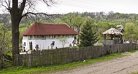
 The Saint Voivodes Church, Mierea | |
 Location in Vâlcea County | |
| Coordinates: 44°42′N 23°50′E / 44.700°N 23.833°E | |
| Country | Romania |
| County | Vâlcea |
| Government | |
| • Mayor (2020–2024) | Iosiv Predescu[1] (PNL) |
Area | 77.25 km2 (29.83 sq mi) |
| Elevation | 238 m (781 ft) |
| Population (2021-12-01)[2] | 1,344 |
| • Density | 17/km2 (45/sq mi) |
| Time zone | EET/EEST (UTC+2/+3) |
| Postal code | 247215 |
| Area code | +(40) 250 |
| Vehicle reg. | VL |
| Website | primariaghioroiu |
Ghioroiu is a commune located in Vâlcea County, Oltenia, Romania. It is composed of six villages: Căzănești, Ghioroiu, Herăști, Mierea, Poienari, and Știrbești.
The commune is situated in the Wallachian Plain, at an altitude of 238 m (781 ft), on the banks of the river Peșteana. It is located in the southwestern part of Vâlcea County, 90 km (56 mi) from the county seat, Râmnicu Vâlcea, on the border with Gorj and Dolj counties.
References
[edit]- ^ "Results of the 2020 local elections". Central Electoral Bureau. Retrieved 9 June 2021.
- ^ "Populaţia rezidentă după grupa de vârstă, pe județe și municipii, orașe, comune, la 1 decembrie 2021" (XLS). National Institute of Statistics.


