Paudalho: Difference between revisions
Appearance
Content deleted Content added
Adding geodata: {{coord missing|Brazil}} |
No edit summary Tags: Mobile edit Mobile web edit |
||
| (56 intermediate revisions by 34 users not shown) | |||
| Line 1: | Line 1: | ||
{{Infobox settlement |
|||
| ⚫ | |||
| official_name = Paudalho |
|||
| native_name = |
|||
| settlement_type = [[Municipalities of Brazil|Municipality]] |
|||
| image_shield = Brasão de Paudalho.jpg |
|||
| image_flag = Bandeira de Paudalho.jpg |
|||
| image_skyline = |
|||
| image_caption = |
|||
| image_map = Mapa Paudalho.png |
|||
| map_caption = Location in Pernambuco state |
|||
| pushpin_map = Brazil |
|||
| pushpin_map_caption = Location in Brazil |
|||
| coordinates = {{coord|7|53|49|S|35|10|48|W|display=inline, title}} |
|||
| subdivision_type = [[List of sovereign states|Country]] |
|||
| subdivision_name = Brazil |
|||
| subdivision_type1 = [[Regions of Brazil|Region]] |
|||
| subdivision_name1 = [[Northeast Region, Brazil|Northeast]] |
|||
| subdivision_type2 = [[States of Brazil|State]] |
|||
| ⚫ | |||
| subdivision_type3 = [[Mesoregions of Brazil|Mesoregion]] |
|||
| subdivision_name3 = [[Zona da Mata]] |
|||
| subdivision_type4 = [[Microregion (Brazil)|Microregion]] |
|||
| subdivision_name4 = [[Mata Setentrional Pernambucana]] |
|||
| subdivision_type5 = [[Metropolitan area#Brazil|Metrop. region]] |
|||
| subdivision_name5 = |
|||
| established_title = Founded |
|||
| established_date = {{start date|4 February 1811}} |
|||
| leader_party = [[Social Democratic Party (Brazil, 2011)|PSD]] |
|||
| leader_title = [[Mayor]] |
|||
| leader_name = Marcello Fuchs Campos Gouveia Filho |
|||
| elevation_m = 69 |
|||
| area_footnotes = |
|||
| area_total_km2 = 277.796 |
|||
| area_metro_km2 = |
|||
| population_footnotes = |
|||
| population_total = 56,933 |
|||
| population_as_of = 2020 <ref>[https://cidades.ibge.gov.br/brasil/pe/paudalho/panorama IBGE 2020]</ref> |
|||
| population_metro = |
|||
| population_density_km2 = auto |
|||
| population_demonym = ''paudalhense'' |
|||
| blank_name_sec1 = [[Human Development Index|HDI]] |
|||
| blank_info_sec1 = |
|||
| timezone1 = [[Time in Brazil|BRT]] |
|||
| utc_offset1 = −3 |
|||
| timezone1_DST = |
|||
| utc_offset1_DST = |
|||
| postal_code_type = Postal code |
|||
| postal_code = 55825-000 |
|||
| area_code_type = [[List of dialling codes in Brazil|Area code]] |
|||
| area_code = 87 |
|||
| website = {{URL|paudalho.pe.gov.br}} |
|||
}} |
|||
| ⚫ | |||
==Geography== |
==Geography== |
||
| ⚫ | |||
* Region - [[Zona da Mata (coastal)|Zona da mata Pernambucana]] |
* Region - [[Zona da Mata (coastal)|Zona da mata Pernambucana]] |
||
* Boundaries - [[ |
* Boundaries - [[Tracunhaém]] ('''N'''), [[São Lourenço da Mata]], [[Chã de Alegria]], [[Camaragibe]] and [[Glória do Goitá]] ('''S'''), [[Carpina]] and [[Lagoa do Itaenga]] ('''W'''), [[Paulista]] and [[Abreu e Lima]] ('''E''') |
||
| ⚫ | |||
* Area - 277.8 sqkm |
|||
| ⚫ | |||
* Elevation - 69 m |
|||
| ⚫ | |||
| ⚫ | |||
| ⚫ | |||
| ⚫ | |||
| ⚫ | |||
| ⚫ | |||
| ⚫ | |||
| ⚫ | |||
==Economy== |
==Economy== |
||
The main economic activities in Paudalho are based in |
The main economic activities in '''Paudalho''' are based in extractive industry, commerce and primary sector especially [[sugarcane]] and [[cattle]]. |
||
===Economic |
===Economic indicators=== |
||
{| class="wikitable" border="1" |
{| class="wikitable" border="1" |
||
|- |
|- |
||
! Population <ref> |
! Population <ref>http://www.ibge.gov.br/home/estatistica/populacao/estimativa2009/POP2009_DOU.pdf [[Brazilian Institute of Geography and Statistics|IBGE]] Population 2009 Paudalho, page 34</ref> |
||
! [[GDP]] x(1000 R$).<ref>[http://www.ibge.com.br/home/estatistica/economia/pibmunicipios/ |
! [[GDP]] x(1000 R$).<ref>[http://www.ibge.com.br/home/estatistica/economia/pibmunicipios/2003_2007/tab01.pdf Paudalho 2007 GDP IBGE page 31] {{webarchive|url=https://web.archive.org/web/20160304001818/http://www.ibge.com.br/home/estatistica/economia/pibmunicipios/2003_2007/tab01.pdf |date=2016-03-04 }}</ref> |
||
! [[GDP per capita|GDP pc]] (R$) |
! [[GDP per capita|GDP pc]] (R$) |
||
! [[Pernambuco|PE]] |
! [[Pernambuco|PE]] |
||
|- |
|- |
||
| 47. |
| 47.551 |
||
| |
| 177.556 |
||
| 3. |
| 3.879 |
||
| 0.29 |
| 0.29% |
||
|- |
|- |
||
|} |
|} |
||
'''Economy by Sector''' |
'''Economy by Sector''' |
||
2006 |
|||
{| class="wikitable" border="1" |
{| class="wikitable" border="1" |
||
|- |
|- |
||
| Line 39: | Line 89: | ||
! [[Service sector]] |
! [[Service sector]] |
||
|- |
|- |
||
| 14.24 |
| 14.24% |
||
| 16.67 |
| 16.67% |
||
| 69.09 |
| 69.09% |
||
|- |
|- |
||
|} |
|} |
||
| Line 49: | Line 99: | ||
{| class="wikitable" border="1" |
{| class="wikitable" border="1" |
||
|- |
|- |
||
! [[HDI]] (2000) |
! [[Human Development Index|HDI]] (2000) |
||
! Hospitals (2007) |
! Hospitals (2007) |
||
! Hospitals beds (2007) |
! Hospitals beds (2007) |
||
! |
! Children's Mortality every 1000 (2005) |
||
|- |
|- |
||
| 0.67 |
| 0.67 |
||
| Line 60: | Line 110: | ||
|- |
|- |
||
|} |
|} |
||
== See also == |
|||
* [[List of municipalities in Pernambuco]] |
|||
==References== |
==References== |
||
{{reflist}} |
{{reflist}} |
||
{{Municipalities of Pernambuco}} |
|||
{{coord missing|Brazil}} |
|||
| ⚫ | |||
| ⚫ | |||
| ⚫ | |||
| ⚫ | |||
Latest revision as of 12:52, 6 December 2024
Paudalho | |
|---|---|
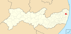
 Location in Pernambuco state | |
| Coordinates: 7°53′49″S 35°10′48″W / 7.89694°S 35.18000°W | |
| Country | Brazil |
| Region | Northeast |
| State | Pernambuco |
| Mesoregion | Zona da Mata |
| Microregion | Mata Setentrional Pernambucana |
| Founded | 4 February 1811 |
| Government | |
| • Mayor | Marcello Fuchs Campos Gouveia Filho (PSD) |
| Area | |
• Total | 277.796 km2 (107.258 sq mi) |
| Elevation | 69 m (226 ft) |
| Population (2020 [1]) | |
• Total | 56,933 |
| • Density | 200/km2 (530/sq mi) |
| Demonym | paudalhense |
| Time zone | UTC−3 (BRT) |
| Postal code | 55825-000 |
| Area code | 87 |
| Website | paudalho |
Paudalho is a city in northeastern Brazil, in the State of Pernambuco.
Geography
[edit]- Region - Zona da mata Pernambucana
- Boundaries - Tracunhaém (N), São Lourenço da Mata, Chã de Alegria, Camaragibe and Glória do Goitá (S), Carpina and Lagoa do Itaenga (W), Paulista and Abreu e Lima (E)
- Hydrography - Capibaribe and Goiana rivers
- Vegetation - Subcaducifólia forest
- Climate - Hot tropical and humid
- Annual average temperature - 25.2 °C (77.4 °F)
- Distance to Recife - 42 kilometres (26 mi)
Economy
[edit]The main economic activities in Paudalho are based in extractive industry, commerce and primary sector especially sugarcane and cattle.
Economic indicators
[edit]| Population [2] | GDP x(1000 R$).[3] | GDP pc (R$) | PE |
|---|---|---|---|
| 47.551 | 177.556 | 3.879 | 0.29% |
Economy by Sector 2006
| Primary sector | Secondary sector | Service sector |
|---|---|---|
| 14.24% | 16.67% | 69.09% |
Health Indicators
[edit]| HDI (2000) | Hospitals (2007) | Hospitals beds (2007) | Children's Mortality every 1000 (2005) |
|---|---|---|---|
| 0.67 | 2 | 114 | 17.3 |
See also
[edit]References
[edit]- ^ IBGE 2020
- ^ http://www.ibge.gov.br/home/estatistica/populacao/estimativa2009/POP2009_DOU.pdf IBGE Population 2009 Paudalho, page 34
- ^ Paudalho 2007 GDP IBGE page 31 Archived 2016-03-04 at the Wayback Machine
- ^ PE State site - City by city profile


