Template:POTD/2016-07-08: Difference between revisions
Appearance
Content deleted Content added
Crisco 1492 (talk | contribs) Creating a WP:POTD template, sourced to Polyconic projection |
Removing reference to deleted Template:POTD protected/2016-07-08. If this bot is malfunctioning, please report it at User:AnomieBOT III/shutoff/POTDPageDeleter |
||
| (5 intermediate revisions by 4 users not shown) | |||
| Line 1: | Line 1: | ||
{{POTD {{{1|{{{style|default}}}}}} |
{{POTD {{{1|{{{style|default}}}}}} |
||
|image=Polyconic projection |
|image=American Polyconic projection.jpg |
||
|size=380 |
|size=380 |
||
|title= [[Polyconic projection|American Polyconic projection]] |
|title= [[Polyconic projection|American Polyconic projection]] |
||
| Line 6: | Line 6: | ||
|caption= |
|caption= |
||
The '''[[Polyconic projection|American Polyconic projection]]''' is a [[map projection]] conceptualized as "rolling" a cone tangent to the Earth at |
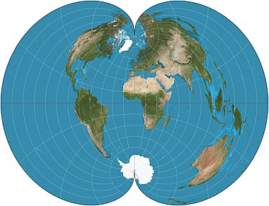
The '''[[Polyconic projection|American Polyconic projection]]''' is a [[map projection]] conceptualized as "rolling" a separate cone tangent to the Earth at each parallel of latitude, rather than a single cone as in a normal conic projection. Each parallel is a circular arc of true scale. The scale is also true on the central meridian of the projection. This projection was in common use by many map-making agencies of the United States from the time of its proposal by [[Ferdinand Rudolph Hassler]] in 1825 until the mid-20th century. |
||
|credit= |
|credit=Map: [[User:Strebe|Strebe]], using Geocart |
||
}}<noinclude>[[Category:Wikipedia Picture of the day {{#time:F Y|{{SUBPAGENAME}}}}]] |
}}<noinclude>[[Category:Wikipedia Picture of the day {{#time:F Y|{{SUBPAGENAME}}}}]] |
||
</noinclude> |
|||
==See also== |
|||
*[[Template:POTD{{#ifeq:{{BASEPAGENAME}}|POTD protected||_protected}}/{{SUBPAGENAME}}]]</noinclude> |
|||
Latest revision as of 00:04, 19 March 2019
The American Polyconic projection is a map projection conceptualized as "rolling" a separate cone tangent to the Earth at each parallel of latitude, rather than a single cone as in a normal conic projection. Each parallel is a circular arc of true scale. The scale is also true on the central meridian of the projection. This projection was in common use by many map-making agencies of the United States from the time of its proposal by Ferdinand Rudolph Hassler in 1825 until the mid-20th century.Map: Strebe, using Geocart

