Dərə Gilətağ: Difference between revisions
Appearance
Content deleted Content added
No edit summary |
Removing geodata: {{coord missing|Azerbaijan}} |
||
| Line 35: | Line 35: | ||
{{Zangilan Rayon}} |
{{Zangilan Rayon}} |
||
{{coord missing|Azerbaijan}} |
|||
{{DEFAULTSORT:Dere Giletag}} |
{{DEFAULTSORT:Dere Giletag}} |
||
[[Category:Populated places in Zangilan District]] |
[[Category:Populated places in Zangilan District]] |
||
Latest revision as of 20:13, 22 June 2021
You can help expand this article with text translated from the corresponding article in Azerbaijani. (March 2021) Click [show] for important translation instructions.
|
Dərə Gilətağ | |
|---|---|
| Coordinates: 39°09′14″N 46°36′49″E / 39.15389°N 46.61361°E | |
| Country | |
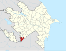
| District | Zangilan |
| Time zone | UTC+4 (AZT) |
| • Summer (DST) | UTC+5 (AZT) |
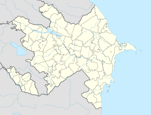
Dərə Gilətağ is a village in the Zangilan District of Azerbaijan.[1]
References
[edit]- ^ Azərbaycan Respublikasının Dövlət Statistika Komitəsi (2019). "İnzibati ərazi bölgüsü təsnifatı" (PDF) (in Azerbaijani). stat.gov.az. Archived from the original (PDF) on 2020-04-16. Retrieved 2021-06-16.


