Nagarkot: Difference between revisions
Appearance
Content deleted Content added
Dr. Blofeld (talk | contribs) No edit summary |
Replacing geodata: {{coord|27.7236|N|85.5247|E|display=title}} |
||
| Line 136: | Line 136: | ||
{{Bagmati-geo-stub}} |
{{Bagmati-geo-stub}} |
||
{{ |
{{coord|27.7236|N|85.5247|E|display=title}} |
||
{{Bhaktapur District}} |
{{Bhaktapur District}} |
||
Revision as of 23:02, 23 September 2008
Nagarkot | |
|---|---|
Village Development Committee | |
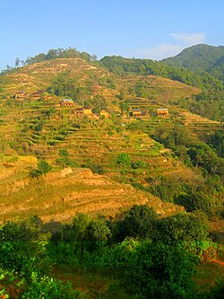
 Crops and houses on the hills of Nagarkot | |
 | |
| Country | |
| Zone | Bagmati Zone |
| District | Bhaktapur District |
| Population (1991) | |
• Total | 3,504 |
| • Religions | Hindu |
| Time zone | UTC+5:45 (Nepal Time) |


Nagarkot is a village and Village Development Committee located 32 km east of Kathmandu, Nepal in Bhaktapur District in the Bagmati Zone. At the time of the 1991 Nepal census it had a population of 3504 and had 655 houses in it.[1] At an elevation of 2,195 meters, it is considered one of the most scenic spots in Bhaktapur District. It is renowned for its sunrise view of the Himalaya including Mount Everest as well as other snow-topped peaks of the Himalayan range of eastern Nepal. Nagarkot also offers a panoramic view of the Kathmandu Valley.[2]
In December 2005, 12 people were killed and 19 were wounded in a shooting incident during a religious festival. The gunman was Basudev Thapa, a soldier based in Nagarkot.[3]
References
- ^ "Nepal Census 2001". Nepal's Village Development Committees. Digital Himalaya. Retrieved 2008-08-26.
- ^ Lonely Planet Nepal, p. 224–225
- ^ Nepali News Daily: The pain of Nagarkot in Nepali media


