Lagawe: Difference between revisions
Appearance
Content deleted Content added
Replacing geodata: {{coord|16|49|N|121|06|E|region:PH_type:city|display=title}} |
|||
| Line 1: | Line 1: | ||
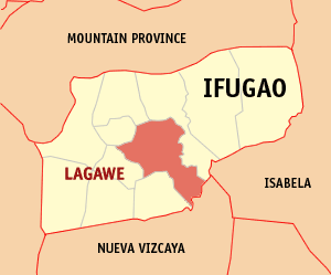
[[Image:Ph_locator_ifugao_lagawe.png|right|Map of Ifugao showing the location of Lagawe]] |
[[Image:Ph_locator_ifugao_lagawe.png|right|Map of Ifugao showing the location of Lagawe]] |
||
'''Lagawe''' is a 4th class [[Philippine municipality|municipality]] in the [[Philippine province|province]] of [[Ifugao province|Ifugao]], [[Philippines]]. It is the capital municipality of Ifugao. According to the |
'''Lagawe''' is a 4th class [[Philippine municipality|municipality]] in the [[Philippine province|province]] of [[Ifugao province|Ifugao]], [[Philippines]]. It is the capital municipality of Ifugao. According to the 2000 census, it has a population of 15,269 people in 2,944 households. |
||
==Barangays== |
==Barangays== |
||
Revision as of 12:04, 11 November 2008

Lagawe is a 4th class municipality in the province of Ifugao, Philippines. It is the capital municipality of Ifugao. According to the 2000 census, it has a population of 15,269 people in 2,944 households.
Barangays
Lagawe is politically subdivided into 20 barangays.
|
|
