Municipality of Hrpelje-Kozina: Difference between revisions
Appearance
Content deleted Content added
m r2.7.1) (Robot: Adding uk:Хрпелє-Козіна |
Deleted link to missing image file |
||
| Line 7: | Line 7: | ||
| image_alt = |
| image_alt = |
||
| image_caption = |
| image_caption = |
||
| image_shield = |
| image_shield = |
||
| image_flag = Zastava Hrpelja-Kozine.svg |
| image_flag = Zastava Hrpelja-Kozine.svg |
||
| shield_alt = |
| shield_alt = |
||
Revision as of 11:31, 13 January 2013
Municipality of Hrpelje–Kozina
Občina Hrpelje - Kozina | |
|---|---|
Town and Municipality | |
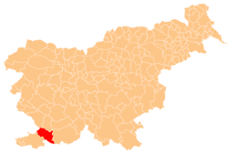
 Location of the Municipality of Hrpelje–Kozina in Slovenia | |
| Country | |
| Government | |
| • Mayor | Albert Pečar |
| Area | |
• Total | 192.2 km2 (74.2 sq mi) |
| Population (2002)[1] | |
• Total | 4,038 |
| • Density | 21/km2 (54/sq mi) |
| Time zone | UTC+01 (CET) |
| • Summer (DST) | UTC+02 (CEST) |
The Municipality of Hrpelje–Kozina (Template:Lang-sl) is a municipality in the Littoral region of Slovenia. Its main settlements are Hrpelje and Kozina.[2]
A major border crossing to Italy is located in the municipality at the village of Krvavi Potok. It connects to Pese di Grozzana in the San Dorligo della Valle comune near Trieste on the Italian side.
References
External links
