Heves County: Difference between revisions
Appearance
Content deleted Content added
CoA |
No edit summary |
||
| Line 3: | Line 3: | ||
<!-- See Template:Infobox settlement for additional fields and descriptions --> |
<!-- See Template:Infobox settlement for additional fields and descriptions --> |
||
| name = Heves County |
| name = Heves County |
||
| image_skyline = |
| image_skyline = Okt 14.jpg |
||
| image_flag = FLAG-Heves-megye.svg |
| image_flag = FLAG-Heves-megye.svg |
||
| image_shield = |
| image_shield = BlasonHU-heves.svg |
||
| image_map = HU county Heves.svg |
| image_map = HU county Heves.svg |
||
| subdivision_type = [[List of sovereign states|Country]] |
| subdivision_type = [[List of sovereign states|Country]] |
||
| Line 23: | Line 23: | ||
==Tourist sights== |
==Tourist sights== |
||
[[ |
[[File:Hungary Noszvaj DeLaMotte palace.jpg|thumb|De la Motte mansion in Noszvaj]] |
||
[[ |
[[File:Kisnána1.jpg|thumb|Castle of Kisnána]] |
||
* [[Lake Tisza]] |
* [[Lake Tisza]] |
||
* [[Bükk National Park]] |
* [[Bükk National Park]] |
||
Revision as of 21:44, 2 December 2014
Heves County | |
|---|---|
 | |
 | |
| Country | Hungary |
| Region | Northern Hungary |
| County seat | Eger |
| Area | |
• Total | 3,637.21 km2 (1,404.33 sq mi) |
| Population (2011 census) | |
• Total | 308,882 |
| • Density | 85/km2 (220/sq mi) |
| Website | www |
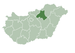
Heves county lies in northern Hungary. It lies between the right bank of the river Tisza and the Mátra and Bükk mountains. It shares borders with the Hungarian counties Pest, Nógrád, Borsod-Abaúj-Zemplén and Jász-Nagykun-Szolnok. Eger is the county seat.
Tourist sights


- Lake Tisza
- Bükk National Park
- Bélapátfalva, abbey
- Castle and City of Eger
- Erdőtelek Arboretum
- Feldebrő, 11th century Romanesque church
- Gyöngyös, Mátra Museum
- Hatvan, Grassalkovich mansion
- Kisnána castle
- Noszvaj, De la Motte mansion
- Parád
- Sirok castle
- Szilvásvárad, Szalajka Valley
- Szarvaskő, castle ruins
Geography
Heves county is a geographically diverse area; its northern part is mountainous (the Mátra and Bükk are the two highest mountain ranges in Hungary), while at south it includes a part of the Great Hungarian Plain. From south it is bordered by Lake Tisza, the largest artificial lake in Hungary. The average temperature is between 8 and 10 °C (higher on the southern parts of the county).
Rivers
Highest point
Lowest point
- Kisköre (86 m.)
Economy
This section is empty. You can help by adding to it. (June 2008) |
History
This section is empty. You can help by adding to it. (June 2008) |
Regional structure
City with county rights

- Eger (county seat)
Towns
(ordered by population, as of 2001)
- Gyöngyös (33,553)
- Hatvan (23,134)
- Heves (11,522)
- Füzesabony (8,335)
- Lőrinci (6,203)
- Bélapátfalva (3,465)
- Kisköre (3,095)
- Pétervására (2,616)
Villages
-
Kisnána - Castle from above
-
Tarnaméra: Aerial Photo of Almássí Castle
-
Pétervására - Palace
-
Noszvaj - Palace De La Motte
-
Erdőtelek - Palace Buttler
-
Mátraderecske - Castle
-
Noszvaj - Palace
-
Aerial photography: Erdőtelek - Palace
-
Feldebrő - Temple from above


