Municipality of Hrpelje-Kozina: Difference between revisions
Appearance
Content deleted Content added
m Robot - Speedily moving category Municipality of Hrpelje–Kozina to Category:Municipality of Hrpelje-Kozina per CFDS. |
change dash back to hyphen, see https://en.wikipedia.org/enwiki/w/index.php?title=Wikipedia:Categories_for_discussion/Speedy&oldid=732632443 |
||
| Line 1: | Line 1: | ||
{{Infobox settlement |
{{Infobox settlement |
||
| name = Municipality of |
| name = Municipality of Hrpelje-Kozina |
||
| native_name = Občina Hrpelje - Kozina |
| native_name = Občina Hrpelje - Kozina |
||
| native_name_lang = sl<!-- ISO 639-2 code e.g. "fr" for French. If more than one, use {{lang}} instead --> |
| native_name_lang = sl<!-- ISO 639-2 code e.g. "fr" for French. If more than one, use {{lang}} instead --> |
||
| Line 14: | Line 14: | ||
| image_map = Karte Hrpelje si.png |
| image_map = Karte Hrpelje si.png |
||
| map_alt = |
| map_alt = |
||
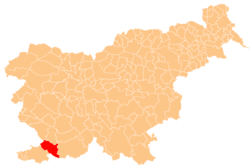
| map_caption = Location of the Municipality of |
| map_caption = Location of the Municipality of Hrpelje-Kozina in Slovenia |
||
| pushpin_map = |
| pushpin_map = |
||
| pushpin_label_position = |
| pushpin_label_position = |
||
| Line 62: | Line 62: | ||
| footnotes = |
| footnotes = |
||
}} |
}} |
||
The '''Municipality of |
The '''Municipality of Hrpelje-Kozina''' ({{lang-sl|Občina Hrpelje - Kozina}}) is a municipality in the [[Slovenian Littoral|Littoral]] region of [[Slovenia]]. Its main settlements are [[Hrpelje]] and [[Kozina]].<ref>[http://www.hrpelje-kozina.si/cms/index.php Hrpelje-Kozina municipal site]</ref> |
||
A major [[border crossing]] to Italy is located in the municipality at the village of [[Krvavi Potok]]. It connects to Pese di Grozzana in the Municipality of [[San Dorligo della Valle]] near [[Trieste]] on the Italian side. |
A major [[border crossing]] to Italy is located in the municipality at the village of [[Krvavi Potok]]. It connects to Pese di Grozzana in the Municipality of [[San Dorligo della Valle]] near [[Trieste]] on the Italian side. |
||
| Line 70: | Line 70: | ||
==External links== |
==External links== |
||
*{{commonscat-inline|Hrpelje - Kozina municipality|Municipality of |
*{{commonscat-inline|Hrpelje - Kozina municipality|Municipality of Hrpelje-Kozina}} |
||
*[http://www.geopedia.si/Geopedia_en.html#L5567_F10131146_vF_b4_x417036.5_y52405.5_s15 Municipality of |
*[http://www.geopedia.si/Geopedia_en.html#L5567_F10131146_vF_b4_x417036.5_y52405.5_s15 Municipality of Hrpelje-Kozina on Geopedia] |
||
{{Hrpelje-Kozina}} |
|||
{{Hrpelje–Kozina}} |
|||
{{Municipalities of Slovenia}} |
{{Municipalities of Slovenia}} |
||
Revision as of 13:40, 2 August 2016
Municipality of Hrpelje-Kozina
Občina Hrpelje - Kozina | |
|---|---|
 Location of the Municipality of Hrpelje-Kozina in Slovenia | |
| Country | |
| Government | |
| • Mayor | Albert Pečar |
| Area | |
• Total | 192.2 km2 (74.2 sq mi) |
| Population (2002)[1] | |
• Total | 4,038 |
| • Density | 21/km2 (54/sq mi) |
| Time zone | UTC+01 (CET) |
| • Summer (DST) | UTC+02 (CEST) |
The Municipality of Hrpelje-Kozina (Template:Lang-sl) is a municipality in the Littoral region of Slovenia. Its main settlements are Hrpelje and Kozina.[2]
A major border crossing to Italy is located in the municipality at the village of Krvavi Potok. It connects to Pese di Grozzana in the Municipality of San Dorligo della Valle near Trieste on the Italian side.
References
External links
 Media related to Municipality of Hrpelje-Kozina at Wikimedia Commons
- Municipality of Hrpelje-Kozina on Geopedia

