Valle Antigorio: Difference between revisions
Appearance
Content deleted Content added
Replacing geodata: {{coord|46.2500|N|8.3250|E|source:wikidata-and-enwiki-cat-tree_region:IT|display=title}} |
Bermicourt (talk | contribs) added Category:Geological type localities using HotCat |
||
| Line 16: | Line 16: | ||
[[Category:Valleys of the Alps]] |
[[Category:Valleys of the Alps]] |
||
[[Category:Valleys of Piedmont]] |
[[Category:Valleys of Piedmont]] |
||
[[Category:Geological type localities]] |
|||
{{Piedmont-geo-stub}} |
{{Piedmont-geo-stub}} |
||
Revision as of 17:59, 2 April 2017

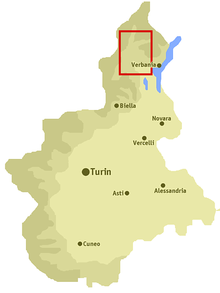
The Antigorio Valley is one of the Alpine valleys radiating from the Ossola Valley (Province of Verbano Cusio Ossola), in the region of Piedmont, northern Italy.
Geography
The River Toce flows across the Antigorio Valley. The valley begins to the south, near Domodossola. It rises to the north, includes the towns of Crevoladossola, Crodo, Baceno and Premia, and it ends in the hamlet of Premia Chioso. As the valley continues to the north it is called Val Formazza. From the town of Baceno it opens to the north-west of the Valley Devero, from which Alpe Devero is reachable..
History
This section is empty. You can help by adding to it. (October 2011) |
Nature
This section is empty. You can help by adding to it. (October 2011) |
