Pathebada: Difference between revisions
Appearance
Content deleted Content added
→top: copyedit |
Wikipedia:Articles for deletion/Pathebada closed as merge to Eluru |
||
| Line 1: | Line 1: | ||
{{Afd-merge to|Eluru|Pathebada|5 June 2017}} |
|||
<!-- Please do not remove or change this AfD message until the discussion has been closed. --> |
|||
{{Article for deletion/dated|page=Pathebada|timestamp=20170520141637|year=2017|month=May|day=20|substed=yes|help=off}} |
|||
<!-- Once discussion is closed, please place on talk page: {{Old AfD multi|page=Pathebada|date=20 May 2017|result='''keep'''}} --> |
|||
<!-- End of AfD message, feel free to edit beyond this point --> |
|||
{{Multiple issues| |
{{Multiple issues| |
||
{{refimprove|date=July 2016}}{{notability|Geography|date=July 2016}}}} |
{{refimprove|date=July 2016}}{{notability|Geography|date=July 2016}}}} |
||
Revision as of 01:21, 5 June 2017
This article was nominated for deletion. The discussion was closed on 5 June 2017 with a consensus to merge the content into the article Eluru. If you find that such action has not been taken promptly, please consider assisting in the merger instead of re-nominating the article for deletion. To discuss the merger, please use the destination article's talk page. (June 2017) |
This article has multiple issues. Please help improve it or discuss these issues on the talk page. (Learn how and when to remove these messages)
|
Pathebada | |
|---|---|
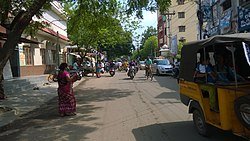
 Road leading from R.R.Pet to Pathebada | |
| Coordinates: 16°42′N 81°06′E / 16.7°N 81.1°E | |
| State | Andhra Pradesh |
| District | West Godavari |
| City | Eluru |
| Languages | |
| • Official | Telugu |
| PIN | 534002 |
| Vehicle registration | AP-37 |
Pathebada is a suburb of Eluru city in Andhra Pradesh, India.[1] It is located in the II-town area of the city.
Transport
Eluru old and new bus stations are the nearest bus stations to Pathebada. Eluru, Powerpet and Vatlurus are nearest railway stations.
References
- ^ Special Correspondent. "ACB slueths seize rs.6 crore worth assets from WG dpo's houses". The New Indian Express.
{{cite web}}:|author=has generic name (help)

