Municipality of Lukovica: Difference between revisions
Appearance
Content deleted Content added
JJMC89 bot (talk | contribs) Migrate {{Infobox settlement}} coordinates parameters to {{Coord}}, see Wikipedia:Coordinates in infoboxes |
pronunciation |
||
| Line 58: | Line 58: | ||
| footnotes = |
| footnotes = |
||
}} |
}} |
||
The '''Municipality of Lukovica''' ({{lang-sl|Občina Lukovica}}) is a municipality in the eastern part of the [[Upper Carniola]] region in [[Slovenia]]. It lies on the main road from [[Ljubljana]] to [[Celje]] and has been an independent municipality since 1995.<ref>[http://www.lukovica.si/prvastran/default-en.asp Lukovica municipal site]</ref> |
The '''Municipality of Lukovica''' ({{IPA-sl|ˈluːkɔʋitsa|pron}}; {{lang-sl|Občina Lukovica}}) is a municipality in the eastern part of the [[Upper Carniola]] region in [[Slovenia]]. It lies on the main road from [[Ljubljana]] to [[Celje]] and has been an independent municipality since 1995.<ref>[http://www.lukovica.si/prvastran/default-en.asp Lukovica municipal site]</ref> |
||
==References== |
==References== |
||
Revision as of 06:25, 10 September 2017
Municipality of Lukovica
Občina Lukovica | |
|---|---|
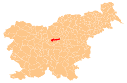
 Location of the Municipality of Lukovica in Slovenia | |
| Coordinates: 46°10′N 14°42′E / 46.167°N 14.700°E | |
| Country | |
| Government | |
| • Mayor | Matej Kotnik |
| Area | |
• Total | 74.9 km2 (28.9 sq mi) |
| Population (2002)[1] | |
• Total | 4,972 |
| • Density | 66/km2 (170/sq mi) |
| Time zone | UTC+01 (CET) |
| • Summer (DST) | UTC+02 (CEST) |
The Municipality of Lukovica (pronounced [ˈluːkɔʋitsa]; Template:Lang-sl) is a municipality in the eastern part of the Upper Carniola region in Slovenia. It lies on the main road from Ljubljana to Celje and has been an independent municipality since 1995.[2]
References
External links
 Media related to Municipality of Lukovica at Wikimedia Commons
- Municipality of Lukovica on Geopedia

