Sarab County: Difference between revisions
Appearance
Content deleted Content added
Rescuing 1 sources and tagging 0 as dead. #IABot (v1.6.5) |
clean up |
||
| Line 40: | Line 40: | ||
|timezone=[[Iran Standard Time|IRST]] |
|timezone=[[Iran Standard Time|IRST]] |
||
|utc_offset=+3:30 |
|utc_offset=+3:30 |
||
|timezone_DST=[[Iran Daylight Time |
|timezone_DST=[[Iran Daylight Time|IRDT]] |
||
|utc_offset_DST=+4:30 |
|utc_offset_DST=+4:30 |
||
|elevation_footnotes = |
|elevation_footnotes = |
||
| Line 62: | Line 62: | ||
[[Category:Sarab County| ]] |
[[Category:Sarab County| ]] |
||
[[Category:Counties of East Azerbaijan Province]] |
[[Category:Counties of East Azerbaijan Province]] |
||
{{Sarab-geo-stub}} |
{{Sarab-geo-stub}} |
||
Revision as of 23:59, 15 August 2019
Sarab County
شهرستان سراب | |
|---|---|
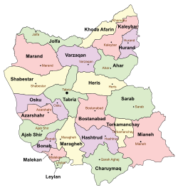
 Location in East Azerbaijan Province | |
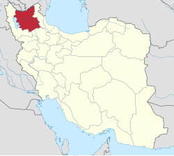
 Location of East Azerbaijan Province in Iran | |
| Country | |
| Province | East Azerbaijan |
| Capital | Sarab |
| Bakhsh (Districts) | Central District, Mehraban District |
| Population (2006) | |
• Total | 132,094 |
| Time zone | UTC+3:30 (IRST) |
| • Summer (DST) | UTC+4:30 (IRDT) |
Sarab County (Template:Lang-fa) is a county in East Azerbaijan Province in Iran. The capital of the county is Sarab. At the 2006 census, the county's population was 132,094, in 31,977 families.[1] The county is subdivided into two districts: the Central District and Mehraban District. The county has four cities: Sarab, Mehraban, Sharabian, and Duzduzan.
References
- ^ "Census of the Islamic Republic of Iran, 1385 (2006)" (Excel). Statistical Center of Iran. Archived from the original on 2011-09-20.
- اطلس گیتاشناسی استانهای ایران [Atlas Gitashenasi Ostanhai Iran] (Gitashenasi Province Atlas of Iran)
Wikimedia Commons has media related to Sarab county.
37°56′23″N 47°32′13″E / 37.939821°N 47.536938°E

