Grodzisk Mazowiecki
Appearance
Grodzisk Mazowiecki | |
|---|---|
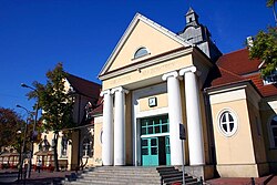
 Railway station | |
| Country | |
| Voivodeship | Masovian |
| County | Grodzisk Mazowiecki County |
| Gmina | Gmina Grodzisk Mazowiecki |
| Town rights | 1522 |
| Government | |
| • Mayor | Grzegorz Józef Benedykciński |
| Area | |
• Total | 13.19 km2 (5.09 sq mi) |
| Population (2006) | |
• Total | 27,055 |
| • Density | 2,100/km2 (5,300/sq mi) |
| Time zone | UTC+1 (CET) |
| • Summer (DST) | UTC+2 (CEST) |
| Postal code | 05-825 to 05-827 |
| Area code | +48 022 |
| Car plates | WGM |
| Website | http://www.grodzisk.pl |
Grodzisk Mazowiecki Template:Audio-IPA-pl is a town in central Poland with 26,881 inhabitants in 2006. It is 30 km. southwest of Warsaw.
Between 1975 and 1998 it was situated in the Warszawa Voivodeship but since 1999 it has been situated in the Masovian Voivodeship. It is the capital of Grodzisk Mazowiecki County.
The town had a Jewish community and it had been the center of the Hasidic Grodzhisk dynasty, (Grodzisk Mazowiecki being pronounced as "Grodzhisk" in Yiddish.)
Wikimedia Commons has media related to Grodzisk Mazowiecki.


