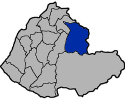
Nanzhuang
Appearance
24°34′12″N 121°00′57″E / 24.569919°N 121.015724°E
Nanzhuang Township 南庄鄉 | |
|---|---|
 | |
 Nanzhuang Township in Miaoli County | |
| Location | Miaoli County, Taiwan |
| Area | |
• Total | 165 km2 (64 sq mi) |
| Population (July 2018) | |
• Total | 10,156 |
| • Density | 62/km2 (160/sq mi) |
| Nanzhuang Township | |
|---|---|
| Chinese | 南庄鄉 |
| Hanyu Pinyin | Nánzhuāng Xiāng |
| Wade–Giles | Nan2-chuang1 Hsiang1 |
| Pha̍k-fa-sṳ | Nàm-chông-hiông |
| Hokkien POJ | Lâm-chng-hiong |
Nanzhuang Township[1] is a rural township in Miaoli County, Taiwan.
Geography
It has a population total of 10,381 (January 2017)[2] and an area of 165.49 square kilometres (63.90 sq mi).
Administrative divisions
The township comprises nine villages: Nanfu, Nanjiang, Penglai, Shishan, Tianmei, Tung, Tunghe, Xi and Yuanlin.[2]
Tourist attractions

- Museum of Saisiat Folklore
- Nanzhuang Old Street
- Quanhua Temple
- Shenxian Valley
- Shitoushan (Lion's Head Mountain) Temple
- Xiangtian Lake[3]
Transportation
- Kaohsiung Xiao-Gang Airport
- Guo-Guang Motor Transit Company
References
- ^ 臺灣地區鄉鎮市區級以上行政區域名稱中英對照表 Glossary of Names for Administrative Divisions. Ministry of the Interior. 26 March Minguo 104 (2015). Retrieved 1 July 2018. Template:Zh icon
- ^ a b 106年一月份人口統計下載區 [January 2017 Population Statistic Downloads]. mlhr.miaoli.gov.tw (in Chinese). Miaoli County Government Household Registration Service. January 2017. Retrieved 2017-02-25.
{{cite web}}: Invalid|script-title=: missing prefix (help) - ^ http://miaolitravel.net/mainweb/article.aspx?Lang=2&Sno=03004314&ET=%&ST=%&KW=&P=1
External links
Wikimedia Commons has media related to Nanzhuang Township, Miaoli.


