Kouhu
23°34′35″N 120°10′21″E / 23.57626°N 120.172523°E
Kouhu Township 口湖鄉 | |
|---|---|
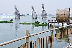
 Chenglong Wetlands in Kouhu Township | |
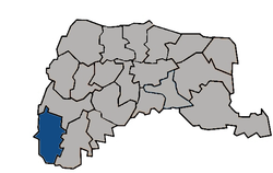
 Kouhu Township in Yunlin County | |
| Location | Yunlin County, Taiwan |
| Area | |
• Total | 80 km2 (30 sq mi) |
| Population (July 2018) | |
• Total | 27,491 |
| • Density | 340/km2 (890/sq mi) |
Kouhu Township (Chinese: 口湖鄉; pinyin: Kǒuhú Xiāng) is a rural township in Yunlin County, Taiwan.
Geography

It has a population total of 29,017 and an area of 80.4612 square kilometers, including a section of coastline bordering the Taiwan Strait.
History
Kouhu's coastal waters were traditionally used in oyster farming, but in 1991 they were zoned for offshore industrial use.[1]
Administrative divisions
The township comprises 21 villages: Chenglong, Dinghu, Gangtung, Gangxi, Guogang, Houcuo, Hukou, Hutung, Jinghan, Keliao, Kouhu, Luntung, Lunjhong, Pubei, Punan, Shueijing, Sialun, Siecuo, Taizih, Wubei, and Wunan.
Infrastructure
Kouhu is one of the area proposed by Taiwan Power Company for underground electricity cable passing through to make a way to Jianshan Village in Huxi Township at Penghu through submarine cable.[2]
Festivals
Tourist attractions
See also
References
- ^ "Yunlin commissioner pleads oyster farmers' case". taipeitimes.com. Retrieved 2017-01-30.
- ^ "EPA gives green light for projects - Taipei Times".
- ^ Yunlin, Cultural Tours in (31 May 2016). "Kouhu Township Qian Shui Che Zhuang Cultural Festival".
- ^ "Art exhibition listings - Taipei Times".
External links
- Kouhu Township Office, Yunlin County (in Chinese)

