Desná (Jablonec nad Nisou District)
Desná | |
|---|---|
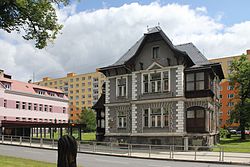
 Town hall | |
| Coordinates: 50°45′35″N 15°18′10″E / 50.75972°N 15.30278°E | |
| Country | |
| Region | Liberec |
| District | Jablonec nad Nisou |
| Founded | 1691 |
| Government | |
| • Mayor | Jaroslav Kořínek |
| Area | |
• Total | 12.58 km2 (4.86 sq mi) |
| Elevation | 490 m (1,610 ft) |
| Population (2024-01-01)[1] | |
• Total | 3,062 |
| • Density | 240/km2 (630/sq mi) |
| Time zone | UTC+1 (CET) |
| • Summer (DST) | UTC+2 (CEST) |
| Postal code | 468 61 |
| Website | mesto-desna |
Desná (Czech pronunciation: [ˈdɛsnaː]; German: Dessendorf) is a town in Jablonec nad Nisou District in the Liberec Region of the Czech Republic. It has about 3,100 inhabitants.
Administrative parts
[edit]Desná consists of the administrative parts of Desná I, Desná II and Desná III.
Geography
[edit]Desná is located about 9 kilometres (6 mi) east of Jablonec nad Nisou. It lies in the Jizera Mountains. The highest point is the mountain Novina at 804 m (2,638 ft) above sea level. The town is situated at the confluence of the Černá Desná and Bílá Desná streams, which form the Desná River. The Souš Reservoir, built on the Černá Desná, is located in the northern part of the municipal territory.
History
[edit]Desná was founded by count Maximilian Desfours II in 1691. Its name supposed to be Desfoursdorf, however the simplified name Dessensdorf was adopted. After almost 250 years, its Czech name Desná was derived. In 1913, Desná was promoted to a market town. In 1949, eleven hamlets or their parts was joined to Desná and the municipality was established in its current form. In 1968, it became a town.[2]
Demographics
[edit]
|
|
| ||||||||||||||||||||||||||||||||||||||||||||||||||||||
| Source: Censuses[3][4] | ||||||||||||||||||||||||||||||||||||||||||||||||||||||||
Transport
[edit]
Desná is located on the railway line Liberec–Szklarska Poręba. The territory is served by four train stations and stops: Desná, Desná-Riedlova vila, Dolní Polubný and Desná-Pustinská.[5]
Sport
[edit]The town is home to the amateur football club TJ Desná.
Sights
[edit]The main landmark of the town is the Church of the Assumption of the Virgin Mary. It was built in the neo-Gothic style in 1903.[6]
Notable people
[edit]- Tomáš Goder (born 1974), ski jumper
Twin towns – sister cities
[edit] Malschwitz, Germany
 Podgórzyn, Poland
References
[edit]- ^ "Population of Municipalities – 1 January 2024". Czech Statistical Office. 2024-05-17.
- ^ "Historie města" (in Czech). Město Desná. Retrieved 2021-08-18.
- ^ "Historický lexikon obcí České republiky 1869–2011" (in Czech). Czech Statistical Office. 2015-12-21.
- ^ "Population Census 2021: Population by sex". Public Database. Czech Statistical Office. 2021-03-27.
- ^ "Detail stanice Bohuňovice" (in Czech). České dráhy. Retrieved 2024-02-27.
- ^ "Kostel Nanebevzetí Panny Marie" (in Czech). National Heritage Institute. Retrieved 2022-11-06.
- ^ "Partnerské obce" (in Czech). Město Desná. Retrieved 2021-08-18.
External links
[edit]


