Jump to content

File:Bering Sea ESA376705.tiff

Page contents not supported in other languages.
This is a file from the Wikimedia Commons
From Wikipedia, the free encyclopedia

Original file (3,903 × 3,955 pixels, file size: 88.35 MB, MIME type: image/tiff)

Summary

Description
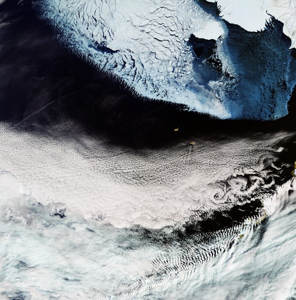
English: The Copernicus Sentinel-3A satellite brings us over the Bering Sea, north of the Alaska Peninsula, on 26 March.

Seasonal sea ice dominates the upper part of the image. Ice plays an important role in the sea’s ecosystem. Growing algae attach to the bottom of the ice; when the ice melts in the spring, it leaves behind a layer of nutrient-rich freshwater on which the algae thrive. Organisms higher up the food chain then eat the algae. In the top-right corner, we can see part of Alaska’s mainland blanketed with snow, as well as Nunivak Island appearing like a massive piece of floating ice. At the centre of the image are the islands of Saint Paul and Saint George – part of the Pribilof Islands. An estimated two million seabirds nest on these islands annually. The swirling clouds on the right side of the image are the result of a meteorological phenomenon known as a von Kármán vortex street. As wind-driven clouds pass over the Unimak Island on the right edge of the image, they flow around the high volcanoes to form the large spinning eddies that can clearly be seen in the image.

This image, also featured on the Earth from Space video programme, was captured by Sentinel-3’s Ocean and Land Colour Instrument, which helps monitor ocean ecosystems, supports crop management and agriculture, and provides estimates of atmospheric aerosol and clouds.
Date
Source http://www.esa.int/spaceinimages/Images/2017/04/Bering_Sea
Author European Space Agency
Permission
(Reusing this file)
contains modified Copernicus Sentinel data (2017), processed by ESA ,CC BY-SA 3.0 IGO
Other versions
Title
InfoField
Bering Sea
System
InfoField
Copernicus
Keywords
InfoField
Sea-ice; Snow; Satellite image; Vortex; Weather systems
Set
InfoField
Earth observation image of the week
Mission
InfoField
Sentinel-3
Activity
InfoField
Observing the Earth

Licensing

w:en:Creative Commons
attribution share alike
This file is licensed under the Creative Commons Attribution-ShareAlike 3.0 IGO license.
You are free:
  • to share – to copy, distribute and transmit the work
  • to remix – to adapt the work
Under the following conditions:
  • attribution – You must give appropriate credit, provide a link to the license, and indicate if changes were made. You may do so in any reasonable manner, but not in any way that suggests the licensor endorses you or your use.
  • share alike – If you remix, transform, or build upon the material, you must distribute your contributions under the same or compatible license as the original.

Captions

Add a one-line explanation of what this file represents

Items portrayed in this file

depicts

28 April 2017

image/tiff

0851e2cd344fba5f4cf8d7dd85f8de1f6bbe3377

92,644,540 byte

3,955 pixel

3,903 pixel

File history

Click on a date/time to view the file as it appeared at that time.

Date/TimeThumbnailDimensionsUserComment
current07:50, 6 May 2017Thumbnail for version as of 07:50, 6 May 20173,903 × 3,955 (88.35 MB)== {{int:filedesc}} == {{information | description = {{en|1=The Copernicus Sentinel-3A satellite brings us over the Bering Sea, north of the Alaska Peninsula, on 26 March. Seasonal sea ice dominates the upper part of the image. Ice plays an important r...

The following page uses this file:

Global file usage

The following other wikis use this file:

Metadata