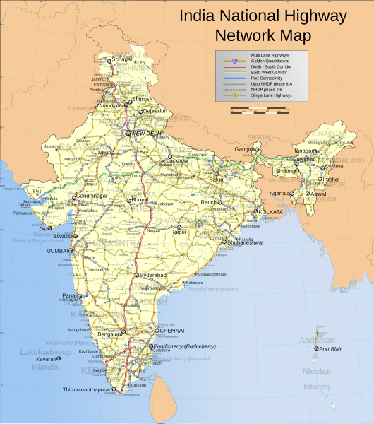
File:India roadway map.svg
Appearance

Size of this PNG preview of this SVG file: 530 × 599 pixels. Other resolutions: 212 × 240 pixels | 425 × 480 pixels | 680 × 768 pixels | 906 × 1,024 pixels | 1,812 × 2,048 pixels | 1,639 × 1,852 pixels.
Original file (SVG file, nominally 1,639 × 1,852 pixels, file size: 1.11 MB)
| This is a featured picture, which means that members of the community have identified it as one of the finest images on the English Wikipedia, adding significantly to its accompanying article. If you have a different image of similar quality, be sure to upload it using the proper free license tag, add it to a relevant article, and nominate it. |
| This image was selected as picture of the day on the English Wikipedia for February 1, 2007. |
File history
Click on a date/time to view the file as it appeared at that time.
| Date/Time | Thumbnail | Dimensions | User | Comment | |
|---|---|---|---|---|---|
| current | 09:58, 2 April 2021 |  | 1,639 × 1,852 (1.11 MB) | JoKalliauer | 1) corrected font-family="'Arial-BoldItalicMT'" and similar to fonts available; 2) put switch at the beginning phab:T279133 3)removed useless clipPaths |
| 13:11, 27 December 2019 |  | 1,639 × 1,852 (1,002 KB) | नीलम | File uploaded using svgtranslate tool (https://tools.wmflabs.org/svgtranslate/). Added translation for hi. | |
| 22:04, 18 August 2018 |  | 1,639 × 1,852 (909 KB) | Cbyneorne | Fixed the spelling of the capital of Mizoram. | |
| 06:14, 2 April 2007 |  | 1,639 × 1,852 (909 KB) | Gmaxwell | Please do not include copyrighted fonts in your SVGs. | |
| 06:13, 2 April 2007 |  | 1,639 × 1,852 (909 KB) | Gmaxwell | Please do not include copyrighted fonts in your SVGs. | |
| 07:33, 9 January 2007 |  | 1,639 × 1,852 (1,001 KB) | Planemad | uttaranchal>uttarkhand, minor color corrections and numbering correction | |
| 17:04, 13 November 2006 |  | 1,639 × 1,852 (1,018 KB) | Planemad | designation for all highways | |
| 10:59, 9 November 2006 |  | 1,639 × 1,852 (865 KB) | Planemad | updated karnataka city spellings, added nh 110 112 113 114 116 117 119 121 123 153 154 155 224 225 226 227, corrections in north east states | |
| 19:31, 6 November 2006 |  | 1,639 × 1,852 (844 KB) | Planemad | nh designation markers on nhdp highways, rivers enabled, lightened state names, 3d locators for capitals and major cities, minor corrections north east areas | |
| 18:01, 15 October 2006 |  | 1,639 × 1,852 (718 KB) | Planemad | Included Nhdp phase IIIA, Changed stroke styles for highways, changed marker locators, added state names, included road legend, added more cities and towns, corrections |
File usage
The following 35 pages use this file:
- Bibliography of India
- National Highways Authority of India
- National Highways Development Project
- National Highways and Infrastructure Development Corporation Limited
- Roads in India
- User:Benipal hardarshan/FNF-pa
- User:JPxG/SP 2006-2010
- User talk:Naveenpf/Archive 2
- User talk:Planemad/Archive 1
- User talk:Planemad/Archive 3
- Wikipedia:Featured picture candidates/India roadway map
- Wikipedia:Featured picture candidates/October-2006
- Wikipedia:Featured pictures/Diagrams, drawings, and maps/Maps
- Wikipedia:Featured pictures thumbs/06
- Wikipedia:Graphics Lab/Map workshop/Archive/Apr 2010
- Wikipedia:Picture of the day/February 2007
- Wikipedia:WikiProject India/Main page featured content
- Wikipedia:WikiProject India/Recognized content
- Wikipedia:WikiProject Indian roads/Recognized content
- Wikipedia:Wikipedia Signpost/2006-10-30/Features and admins
- Wikipedia:Wikipedia Signpost/2006-10-30/SPV
- Wikipedia:Wikipedia Signpost/Single/2006-10-30
- Wikipedia talk:WikiProject Indian maps/Archive 1
- Wikipedia talk:WikiProject Indian roads/Archive 1
- Template:POTD/2007-02-01
- Portal:India/Picture of the week, 2006
- Portal:India/Picture of the week 45, 2006
- Portal:India/Recognized content
- Portal:India/SC Summary/SP India roadway map
- Portal:India/Selected picture
- Portal:India/Selected picture/23
- Portal:India/Selected picture candidates/Archived nominations
- Portal:India/Selected picture candidates/India roadway map
- Portal:Maps/Selected picture
- Portal:Maps/Selected picture/17
Global file usage
The following other wikis use this file:
- Usage on af.wikipedia.org
- Usage on as.wikipedia.org
- Usage on ba.wikipedia.org
- Usage on be-tarask.wikipedia.org
- Usage on bh.wikipedia.org
- Usage on bn.wikipedia.org
- Usage on ce.wikipedia.org
- Usage on crh.wikipedia.org
- Usage on cv.wikipedia.org
- Usage on de.wikipedia.org
- Usage on eu.wikipedia.org
- Usage on fi.wikipedia.org
- Usage on fr.wikipedia.org
- Usage on gor.wikiquote.org
- Usage on gu.wikipedia.org
- Usage on ha.wikipedia.org
- Usage on hif.wikipedia.org
- Usage on hi.wikipedia.org
- Usage on hu.wikipedia.org
- Usage on id.wikipedia.org
- Usage on incubator.wikimedia.org
- Usage on it.wikipedia.org
- Usage on kk.wikipedia.org
- Usage on kn.wikipedia.org
- Usage on ko.wikipedia.org
- Usage on la.wikipedia.org
View more global usage of this file.


