Mutxamel
Appearance
Mutxamel
| |
|---|---|
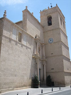
 Church of The Holy Saviour | |
| Coordinates: 38°24′49″N 0°26′44″W / 38.41361°N 0.44556°W | |
| Country | |
| Autonomous community | |
| Province | Alicante |
| Comarca | Alacantí |
| Judicial district | Sant Vicent del Raspeig |
| Government | |
| • Alcalde | Sebastián Cañadas Gallardo (2015) (PP) |
| Area | |
• Total | 47.67 km2 (18.41 sq mi) |
| Elevation | 63 m (207 ft) |
| Population (2018)[1] | |
• Total | 25,009 |
| • Density | 520/km2 (1,400/sq mi) |
| Demonym(s) | mutxameler, mutxamelera (in Catalan) muchamelero, muchamelera (in Spanish) |
| Time zone | UTC+1 (CET) |
| • Summer (DST) | UTC+2 (CEST) |
| Postal code | 03110 |
| Official language(s) | Valencian |
Mutxamel (Valencian: [mutʃaˈmɛl]; Spanish: Muchamiel [mutʃaˈmjel]) is a municipality in the comarca of Alacantí, Alicante, Valencian Community, Spain.
References
[edit]- ^ Municipal Register of Spain 2018. National Statistics Institute.


