Oakenholt
Appearance
| Oakenholt | |
|---|---|
 Victorian terrace, Oakenholt | |
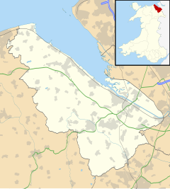
Location within Flintshire | |
| Population | 2,920 (2001 Census)[1] |
| OS grid reference | SJ2671 |
| Community | |
| Principal area | |
| Preserved county | |
| Country | Wales |
| Sovereign state | United Kingdom |
| Post town | FLINT |
| Postcode district | CH6 |
| Dialling code | 01352 |
| Police | North Wales |
| Fire | North Wales |
| Ambulance | Welsh |
| UK Parliament | |
| Senedd Cymru – Welsh Parliament | |
Oakenholt is a village in Flintshire, Wales. It is situated to the south east of the town of Flint, near the A548 road. At the 2001 Census, the population of the Flint Oakenholt Ward was 2920.[1]
In 2017 a major archaeological excavation began in the village to find evidence of any settlement during the Roman occupation of Britain.[2]
References
[edit]- ^ a b 2001 Census: Flint Oakenholt (Ward), Office for National Statistics, retrieved 25 September 2008
- ^ "Roman artefacts the target of Oakenholt excavation". BBC News. 7 October 2017.
External links
[edit]Wikimedia Commons has media related to Oakenholt.


