Paljassaare
Paljassaare | |
|---|---|
Subdistrict of Tallinn | |
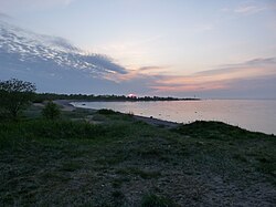
 The shoreline on the northeastern side of Paljassaare. | |
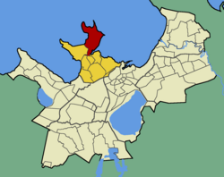
 Paljassaare within Põhja-Tallinn. | |
| Country | |
| County | |
| City | |
| District | |
| Population (01.01.2014[1]) | |
• Total | 583 |
Paljassaare (Estonian for "Bare Island") is the name of the Paljassaare Peninsula in the Tallinn Bay, and the name of a subdistrict (Estonian: asum) in the district of Põhja-Tallinn (Northern Tallinn) in the city of Tallinn, the capital of Estonia. The subdistrict is located on the peninsula.
Paljassaare has a population of 583 (As of 1 January 2014[update]).[1]
Paljassaare Harbour
[edit]The Paljassaare Harbour is a cargo port, which primarily specialises in handling mixed cargo, coal and oil products, as well as timber and perishables. The harbour is also used by the neighbouring refinery for cooking oil shipments.
The harbour has an area of 43.6 ha and has 11 berths.
Vessels enter and leave the harbour through a canal, which is 800 metres long, 90-150 metres wide, and 9.0 metres deep.
- Terminals of Paljassaare Harbour
- oil terminal
- cooking oil terminal
- timber terminal
- coal terminal
- general cargo terminals (including a reefer terminal)
- dry bulk terminal
Gallery
[edit]-
View at Paljassaare Peninsula from Kopli Peninsula.
-
Tallinn sewage treatment plant in the middle of Paljassaare
-
A marine radar tower on the cape of Väike-Paljassaar ("Small Paljassaar").
-
Pikakari beach in Tallinn
-
Former military structure now used as an observation platform.
-
View towards Suur-Paljassaar ("Great Paljassaar").
-
Caves full of water
References
[edit]- ^ a b "Statistical Yearbook of Tallinn 2014". Tallinn City Government. p. 52. Archived from the original on 17 July 2015. Retrieved 27 November 2014.


