Strážné
Strážné | |
|---|---|
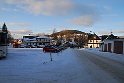
 Centre of Strážné | |
| Coordinates: 50°40′7″N 15°37′5″E / 50.66861°N 15.61806°E | |
| Country | |
| Region | Hradec Králové |
| District | Trutnov |
| First mentioned | 1754 |
| Area | |
• Total | 17.68 km2 (6.83 sq mi) |
| Elevation | 798 m (2,618 ft) |
| Population (2024-01-01)[1] | |
• Total | 224 |
| • Density | 13/km2 (33/sq mi) |
| Time zone | UTC+1 (CET) |
| • Summer (DST) | UTC+2 (CEST) |
| Postal code | 543 52 |
| Website | www |
Strážné (German: Pommerndorf) is a municipality and village in Trutnov District in the Hradec Králové Region of the Czech Republic. It has about 200 inhabitants. It lies in the Giant Mountains.
Geography
[edit]Strážné is located about 23 kilometres (14 mi) northwest of Trutnov and 39 km (24 mi) east of Liberec. It lies in the Giant Mountains and in the Krkonoše National Park. The highest point is the mountain Liščí hora at 1,363 m (4,472 ft) above sea level. The Malé Labe River originates near the northern municipal border, forms part of the municipal border and then flows across the municipality.
History
[edit]The iron ore was mined in the area probably already in the 15th century, and in the 16th century, mining was at its peak. However, a settlement was founded here later. The first written mention Strážné is from 1754, that time under the name Pommerndorf. According to legends, it was founded by exiled people from Pomerania during the Thirty Years' War. The area of today's Strážné also included the village of Herlíkovice.[2]
In 1792, the mining stopped. The source of livelihood then became forestry, cattle breeding and textile industry. Since the 19th century, tourism is developing. In 1945, the German population was expelled and the area significantly depopulated. Therefore, in 1951 Herlíkovice was abolished, and its territory was divided between Strážné and Vrchlabí.[2]
Demographics
[edit]
|
|
| ||||||||||||||||||||||||||||||||||||||||||||||||||||||
| Source: Censuses[3][4] | ||||||||||||||||||||||||||||||||||||||||||||||||||||||||
Transport
[edit]There are no railways or major roads passing through the municipality.
Sport
[edit]In the municipality is a ski resort with four ski slopes.[5]
Sights
[edit]
The main landmark is the Art Nouveau building of the Evangelical church in the former village of Herlíkovice. It was built in 1903–1904 according to the design by Schilling & Graebner.[6]
Notable people
[edit]- Johann Lahr (1913–1942), ski jumper
References
[edit]- ^ "Population of Municipalities – 1 January 2024". Czech Statistical Office. 2024-05-17.
- ^ a b "Historie obce Strážné" (in Czech). Obec Strážné. Retrieved 2021-09-24.
- ^ "Historický lexikon obcí České republiky 1869–2011" (in Czech). Czech Statistical Office. 2015-12-21.
- ^ "Population Census 2021: Population by sex". Public Database. Czech Statistical Office. 2021-03-27.
- ^ "Skiareál Strážné" (in Czech). Obec Strážné. Retrieved 2021-09-24.
- ^ "Kostel evangelický" (in Czech). National Heritage Institute. Retrieved 2023-11-17.
External links
[edit]


