Sarab County: Difference between revisions
Appearance
Content deleted Content added
Adding geodata: {{coord|37.939821|N|47.536938|E|type:adm2nd_source:itwiki|display=title}} |
m Bot: Migrating 7 interwiki links, now provided by Wikidata on d:q1291800 (Report Errors) |
||
| Line 63: | Line 63: | ||
{{EastAzarbaijan-geo-stub}} |
{{EastAzarbaijan-geo-stub}} |
||
{{East Azerbaijan Province}} |
{{East Azerbaijan Province}} |
||
[[az:Sarab şəhristanı]] |
|||
[[fa:شهرستان سراب]] |
|||
[[it:Provincia di Sarab]] |
|||
[[pnb:شہرستان سراب]] |
|||
[[sh:Okrug Sarob]] |
|||
[[tg:Шаҳристони Сароб]] |
|||
[[tr:Serab şehristanı]] |
|||
Revision as of 20:14, 26 February 2013
Sarab County
شهرستان سراب | |
|---|---|
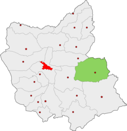
 Location of Sarab County in East Azerbaijan Province | |
| Country | |
| Province | East Azerbaijan |
| Capital | Sarab |
| Bakhsh (Districts) | Central District, Mehraban District |
| Population (2006) | |
• Total | 132,094 |
| Time zone | UTC+3:30 (IRST) |
| • Summer (DST) | UTC+4:30 (IRDT) |
Sarab County (Template:Lang-fa) is a county in East Azerbaijan Province in Iran. The capital of the county is Sarab. At the 2006 census, the county's population was 132,094, in 31,977 families.[1] The county is subdivided into two districts: the Central District and Mehraban District. The county has four cities: Sarab, Mehraban, Sharabian, and Duzduzan.
References
- ^ "Census of the Islamic Republic of Iran, 1385 (2006)" (Excel). Statistical Center of Iran. Archived from the original on 2011-09-20.
- اطلس گیتاشناسی استانهای ایران [Atlas Gitashenasi Ostanhai Iran] (Gitashenasi Province Atlas of Iran)

